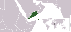
Arkivo:LocationSouthYemen.png

Paĝenhavo ne ekzistas en aliaj lingvoj.
De Wikipedio

LocationSouthYemen.png(250 × 115 pixel-i, grandeso dil arkivo: 6 KB, MIME type: image/png)

Ca arkivo jacas en Wikimedia Commons, e povas uzesar en altra projeti. La deskriptado en lua pagino di deskriptado montresas adinfre.

Titulo

English: Locator map of the People's Democratic Republic of Yemen (1967 - 1990).
  • A Soviet Socialist satellite nation in Arabia.
  • Formerly located in present day southern Yemen.

This image was copied from wikipedia:en. The original description was:

Map showing South Yemen.

(Note: This map is old and therefore shows Eritrea as being part of Ethiopia)

GNU head On darfas kopiigar, distributar ed/od altrigar ica dokumento segun la kondicioni di GNU Free Documentation License, quale esas mencionita en la versiono 1.2 od en irga plu posa versiono, qua esas publikigita da Free Software Foundation; En la dokumento ne darfas esas ne-altrigita parti ed olu ne darfas esar kom texto di frontala o dopala pagino di libro o GNU Free Documentation License.
w:eo:Creative Commons
Atribuo partigar identa ('share alike')
Ica arkivo liberigesas sub permiso Creative Commons Attribution-Share Alike 3.0 Unported.
Vu povas:
  • partigar – kopiar, distributar e transsendar la verko
  • Mixar – adaptar l'arkivo
Segun la sequanta kondicioni:
  • Atribuo – Vu mustas referar l'artiklo o verko segun la formo definita dal autoro o dal proprietero dil autoroyuro, ed informar se modifikuri facesis. Vu mustas facar to per justa formo, ma ne insinuar ke l'autoro konfidis ol a vu, od aprobis vua uzo dil artiklo.
  • partigar identa ('share alike') – Se vu modifikos, transformos od augmentos ica verko, vu mustos distributar la rezulto segun la sama, o simila licenco, quale l'originalo.
Ica etiketo pri uzo-permiso ligesis ad ica artiklo dum l'aktualigo dil yurizo GFDL.
date/time username edit summary
14:58, 27 December 2004 Quadell ({{GFDL}})
18:57, 26 May 2004 66.30.125.123
22:24, 24 February 2004 Morwen (map showing <a href="/wiki/South_Yemen" title="South Yemen">South Yemen</a>)

Titoloj

Adjuntez 1 lineo explikanta quo reprezentas ca arkivo

Kozi montrata en ca arkivo

montras Esperanto

sub kopirajto Esperanto

Historio dil arkivo

Kliktez sur la dato/horo por vidar arkivo quale ol aparis ye ta tempo.

Dato/HoroMiniaturoDimensioniUzeroKomento
aktuala18:56, 4 jun. 2009Imajeto di versiono ye 18:56, 4 jun. 2009250 × 115 (6 KB)HoshieFix the borders based on this map: http://www.lib.utexas.edu/maps/middle_east_and_asia/middle_east_pol_1976.jpg
11:08, 25 sep. 2007Imajeto di versiono ye 11:08, 25 sep. 2007250 × 115 (6 KB)Hoshiereadded the YAR/PDRY/Saudi Arabia boundary. The boundaries during this time in this region were (and in some cases, still are) disputed, undemarcated, or demarcated but undisclosed to the rest of the world.
07:37, 27 sep. 2006Imajeto di versiono ye 07:37, 27 sep. 2006250 × 115 (6 KB)HoshieI have corrected the boundry between the YAR and PDRY. The boundry then was unsettled. See this 1976 map: http://www.lib.utexas.edu/maps/middle_east_and_asia/middle_east_pol_1976.jpg Under same license as original.
22:02, 14 feb. 2006Imajeto di versiono ye 22:02, 14 feb. 2006250 × 115 (6 KB)Ingc~commonswikiLocation Map of Democratic Popoular Yemen. {{PD}} source:"http://en.wikipedia.org/wiki/Repubblica_Democratica_Popolare_dello_Yemen"
11:59, 11 okt. 2005Imajeto di versiono ye 11:59, 11 okt. 2005250 × 115 (6 KB)ChongDaeThis image was copied from wikipedia:en. The original description was: Map showing South Yemen.<br> <br> <i>(Note: This map is old and therefore shows Eritrea as being part of Ethiopia)</i> {{GFDL}} {| border="1" ! date/time || username || edit summ

Nula pagino ligesas ad ica pagino.