
Arkivo:Adyar estuary.jpg

Grandeso de ica previdado: 800 x 364 pixels. Altra qualeso, en pixel-i: 320 x 146 pixels | 640 x 291 pixels | 1 443 x 657 pixels.
Arkivo originala (1 443 × 657 pixel-i, grandeso dil arkivo: 249 KB, MIME type: image/jpeg)
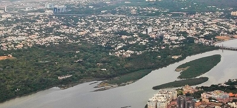
| Deskripto | Aerial view of the Adyar Estuary and w:Adyar. On the top ind is w:Tidel Park and the w:Chennai MRTS. The gardens belong to the w:Theosophical Society. | ||
| Dato | 22 June 05 | ||
| Fonto | Propra verko | ||
| Autoro |
|
||
| Yurizo (Riuzo di ica arkivo) |
Me, la posedanto dil autoroyuro pri ica imajo/arkivo, permisos lua uzado camaniere: Ĉi tiu dosiero estas disponebla laŭ la permesilo Krea Komunaĵo Atribuite-Samkondiĉe 2.5 Ĝenerala.
|
| Pozicio de la fotilo | | Tiu cxi bildo kaj pliaj sur OpenStreetMap |
|---|
Historio dil arkivo
Kliktez sur la dato/horo por vidar arkivo quale ol aparis ye ta tempo.
| Dato/Horo | Miniaturo | Dimensioni | Uzero | Komento | |
|---|---|---|---|---|---|
| aktuala | 12:16, 28 apr. 2007 | | 1 443 × 657 (249 KB) | Planemad | {{Information |Description=Aerial view of the Adyar Estuary and w:Adyar. On the top ind is w:Tidel Park and the w:Chennai MRTS. |Source=own work |Date= 22 June 05 |Author= w:user:PlaneMad |Permission={{self|cc-by-sa-2.5}} |
Ligilo al imajo
Ca pagini ligas al imajo:
Uzado en altra Wiki
La sequanta Wiki anke uzas ica arkivo:
- Uzado en arz.wikipedia.org
- Uzado en azb.wikipedia.org
- Uzado en bg.wikipedia.org
- Uzado en bn.wikipedia.org
- Uzado en ceb.wikipedia.org
- Uzado en cs.wikipedia.org
- Uzado en de.wikipedia.org
- Uzado en en.wikipedia.org
- Uzado en es.wikipedia.org
- Uzado en fa.wikipedia.org
- Uzado en fi.wikipedia.org
- Uzado en fr.wikipedia.org
- Uzado en hi.wikipedia.org
- Uzado en id.wikipedia.org
- Uzado en incubator.wikimedia.org
- Uzado en it.wikipedia.org
- Uzado en jv.wikipedia.org
- Uzado en ml.wikipedia.org
- Uzado en nl.wikipedia.org
- Uzado en no.wikipedia.org
- Uzado en pt.wikipedia.org
- Uzado en ro.wikipedia.org
- Uzado en ru.wikipedia.org
- Uzado en ta.wikipedia.org
- Uzado en uk.wikipedia.org
- Uzado en ur.wikipedia.org
- Uzado en www.wikidata.org
- Uzado en zh-min-nan.wikipedia.org
- Uzado en zh-yue.wikipedia.org