
Arkivo:Cape Helles landing map.jpg
Grandeso de ica previdado: 789 x 599 pixels. Altra qualeso, en pixel-i: 316 x 240 pixels | 632 x 480 pixels | 845 x 642 pixels.
Arkivo originala (845 × 642 pixel-i, grandeso dil arkivo: 72 KB, MIME type: image/jpeg)
Titulo
| Deskripto |
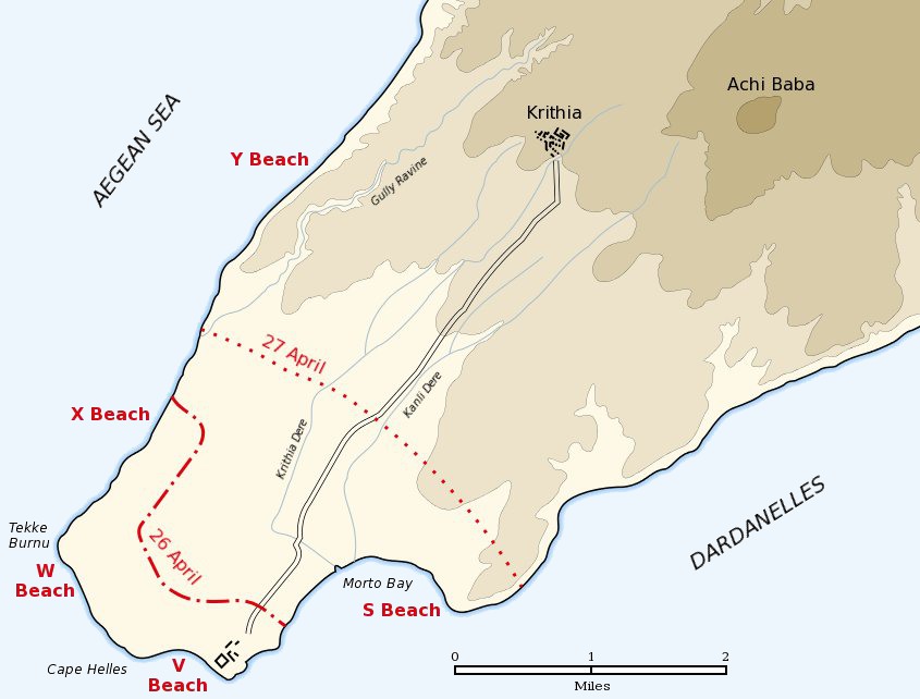
English: Map of the landing of the British 29th Division at Cape Helles on April 25, 1915 during the Battle of Gallipoli. The front line established by the night of April 26 is shown by the red dash-dot line. The front line reached by the night of April 27 is shown by the red dotted line. This became the "jumping off" line for the First Battle of Krithia. |
||
| Dato | |||
| Fonto | Self created from map [1] in Hamilton, Ian (1920) Gallipoli Diary, Volume I, Category:New York: George H Doran Company | ||
| Autoro | Gsl | ||
| Yurizo (Riuzo di ica arkivo) |
|
||
| Altra versioni |
|


![[1]](http://gutenberg.readingroo.ms/1/9/3/1/19317/19317-h/images/img-map.jpg)
Originala protokolo dum sendado dil arkivo
The original description page was Helles landing map.jpg here. All following user names refer to en.wikipedia.
- 2004-05-16 06:37 Gsl 845×642× (64213 bytes)
Historio dil arkivo
Kliktez sur la dato/horo por vidar arkivo quale ol aparis ye ta tempo.
| Dato/Horo | Miniaturo | Dimensioni | Uzero | Komento | |
|---|---|---|---|---|---|
| aktuala | 18:20, 21 jun. 2012 | | 845 × 642 (72 KB) | Hohum | Sea to blue |
| 15:04, 6 may. 2005 |  | 845 × 642 (63 KB) | Anathema | Map of the landing of the British 29th Division at Cape Helles, Gallipoli, on April 25, 1915. The front line established by the night of April 26 is shown by the red dash-dot line. The front line reached by the night of April 27 is shown by the red |
Ligilo al imajo
Ca pagini ligas al imajo:
Uzado en altra Wiki
La sequanta Wiki anke uzas ica arkivo:
- Uzado en ar.wikipedia.org
- Uzado en ast.wikipedia.org
- Uzado en bg.wikipedia.org
- Uzado en ca.wikipedia.org
- Uzado en cs.wikipedia.org
- Uzado en da.wikipedia.org
- Uzado en de.wikipedia.org
- Uzado en en.wikipedia.org
- Uzado en fr.wikipedia.org
- Uzado en fy.wikipedia.org
- Uzado en he.wikipedia.org
- Uzado en id.wikipedia.org
- Uzado en it.wikipedia.org
- Uzado en ko.wikipedia.org
- Uzado en no.wikipedia.org
- Uzado en pl.wikipedia.org
- Uzado en pt.wikipedia.org
- Uzado en ro.wikipedia.org
- Uzado en ru.wikipedia.org
- Uzado en sr.wikipedia.org
- Uzado en uk.wikipedia.org