
Arkivo:Dissolution of Austria-Hungary.png
Grandeso de ica previdado: 800 x 473 pixels. Altra qualeso, en pixel-i: 320 x 189 pixels | 640 x 378 pixels | 1 024 x 605 pixels | 1 641 x 970 pixels.
Arkivo originala (1 641 × 970 pixel-i, grandeso dil arkivo: 182 KB, MIME type: image/png)

|
Tiu ĉi bildo map respektive ĉiuj bildoj en tiu ĉi artikolo aŭ kategorio prefere estu rekreata(j) kiel vektora grafikaĵo en la formato SVG. Vektoraj formatoj por grafikaĵoj havas multajn avantaĝojn, detaloj troveblas anglalingve en la komuneja artikolo Commons:Media for cleanup. Se vi havas aŭ kreas SVG-version de tiu ĉi bildo, bonvolu alŝuti ĝin al la vikipedia komunejo. Post tiu ago, ĉi tiu ŝablono en la bildpaĝo estas anstataŭigenda per la ŝablono {{vector version available|nova dosiera nomo.svg}}.
|
| Deskripto |
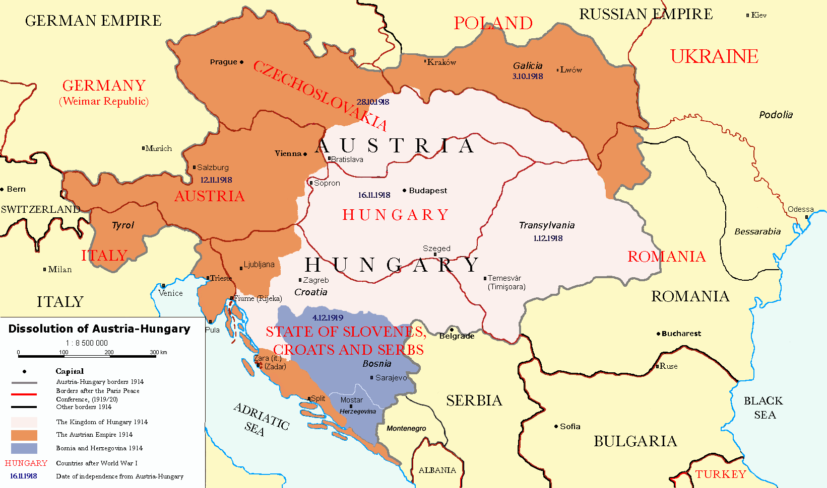
Čeština: Rozdělení Rakouska-Uherska po první světové válce, podle Pařížských předměstských smluv (Versailles s Německem, Saint-Germain-en-Laye s Rakouskem, Neuilly-sur-Seine s Bulharskem, Trianon s Maďarskem, Sèvres s Tureckem), dojednaných na Pařížské mírové konferenci (1919). Deutsch: Das Ende Österreich-Ungarns nach den Pariser Vorortverträgen. English: The end of Austria-Hungary after the Paris Treaty. Border of Austria-Hungary in 1914 Borders in 1914 Borders in 1920 Austrian Empire in 1914 Kingdom of Hungary in 1914 Bosnia and Herzegovina in 1914 |
| Dato | (UTC) |
| Fonto | |
| Autoro |
|
| Altra versioni | العربيَّة |
| Ĉi tio estas modifita bildo, kio signifas, ke ĝi ekestis per cifereca aliigo de la origina versio. Modifoj: translated to english. La originaĵo videblas ĉi tie: Österreich-Ungarns Ende.png. La modifojn faris P. S. Burton.
|
Me, la proprietero dil autoroyuri pri ica verko, per to publikigos ol segun la sequanta yurizi:
| Ica arkivo liberigesas sub permiso Creative Commons Attribution-Share Alike 3.0 Unported. | ||
| ||
| Ica etiketo pri uzo-permiso ligesis ad ica artiklo dum l'aktualigo dil yurizo GFDL. |

|
On darfas kopiigar, distributar ed/od altrigar ica dokumento segun la kondicioni di GNU Free Documentation License, quale esas mencionita en la versiono 1.2 od en irga plu posa versiono, qua esas publikigita da Free Software Foundation; En la dokumento ne darfas esas ne-altrigita parti ed olu ne darfas esar kom texto di frontala o dopala pagino di libro o GNU Free Documentation License. |
Selektez l'yurizo quon vu preferas.
Originala protokolo dum sendado dil arkivo
This image is a derivative work of the following images:
- File:Österreich-Ungarns_Ende.png licensed with Cc-by-sa-3.0-migrated, GFDL
- 2007-07-16T11:59:46Z Nihad Hamzic 1568x970 (81916 Bytes) The original image seems to had been saved as JPEG, and that some previous uploader had simply directly converted it to PNG. I have greatly optimised its size by removing JPEG artifacts, reducing color domain, etc.
- 2006-01-23T20:47:06Z AlphaCentauri 1568x970 (924912 Bytes) kleine Änderungen
- 2005-09-23T14:27:32Z AlphaCentauri 1568x970 (924912 Bytes) Laibach and Triest
- 2005-09-17T03:29:55Z Berkut 1568x970 (355556 Bytes) better file compression
- 2005-09-16T09:39:55Z Kallgan 1568x970 (438065 Bytes) Das Ende Österreich-Ungarns nach dem Pariser Vorortverträgen. Selbsterstellte Karte. {{Bild-GFDL}} (Borders between Romania and Bulgaria in Dobrogea modified)(Source: Goode's World Atlas, Rand McNally & Company, 1932 & 19
- 2005-07-04T13:39:25Z AlphaCentauri 1568x970 (924912 Bytes) verbessert
- 2005-04-28T19:29:14Z AlphaCentauri 1568x970 (924912 Bytes) so, nochmals verbessert
- 2005-04-12T18:45:25Z AlphaCentauri 1568x970 (924912 Bytes) nochmals verbessert
- 2005-04-12T15:06:42Z AlphaCentauri 1568x970 (924912 Bytes)
- 2005-04-12T14:47:08Z AlphaCentauri 1568x970 (924912 Bytes) verbesserte Version
- 2005-01-05T20:59:50Z AlphaCentauri 1568x970 (924912 Bytes) verbesserte Version
- 2004-12-29T10:14:48Z AlphaCentauri 1568x970 (924912 Bytes) Das Ende Österreich-Ungarns (Karte)
Uploaded with derivativeFX
Historio dil arkivo
Kliktez sur la dato/horo por vidar arkivo quale ol aparis ye ta tempo.
| Dato/Horo | Miniaturo | Dimensioni | Uzero | Komento | |
|---|---|---|---|---|---|
| aktuala | 17:57, 26 dec. 2021 | | 1 641 × 970 (182 KB) | Claude Zygiel | Cosmetic and correct romanian-ukrainian border since April 9, 1918 |
| 16:27, 6 dec. 2020 |  | 1 568 × 970 (175 KB) | Crash48 | before 1919, the Greek-Bulgarian border was far to the southwest | |
| 18:08, 3 dec. 2020 |  | 1 568 × 970 (175 KB) | Crash48 | Lwów didn't become Lviv until 1939 | |
| 16:37, 2 dec. 2020 |  | 1 568 × 970 (148 KB) | Crash48 | Romanian-Ukrainian border was way off; fixed according to File:Romania1901.JPG | |
| 15:20, 10 mar. 2020 |  | 1 568 × 970 (229 KB) | Kufl | Odessa was never part of the Romania at that time | |
| 15:58, 10 okt. 2013 |  | 1 568 × 970 (163 KB) | Lvivske | Incorrectly states that Ukraine was the Russian SFSR (Russia is not seen on the map), the area of Ukraine was the Ukraine post-WW1 and later following another war, the Ukrainian Soviet Socialist Republic, and joined ... | |
| 21:36, 24 nov. 2010 |  | 1 568 × 970 (164 KB) | P. S. Burton | Ungarn ->Hungary etc. | |
| 21:46, 23 nov. 2010 |  | 1 568 × 970 (163 KB) | P. S. Burton | Zara -> Zara (Zadar) | |
| 21:41, 23 nov. 2010 |  | 1 568 × 970 (163 KB) | P. S. Burton | Black Sea ->BLACK SEA | |
| 21:39, 23 nov. 2010 |  | 1 568 × 970 (163 KB) | P. S. Burton | {{Information |Description={{cs|Rozdělení Rakouska-Uherska po první světové válce, podle Pařížských předměstských smluv ([[:cs:Versailles|Ver |
Ligilo al imajo
Ca pagini ligas al imajo:
Uzado en altra Wiki
La sequanta Wiki anke uzas ica arkivo:
- Uzado en ar.wikipedia.org
- Uzado en azb.wikipedia.org
- Uzado en ba.wikipedia.org
- Uzado en ca.wikipedia.org
- Uzado en de.wikipedia.org
- Uzado en el.wikipedia.org
- Uzado en en.wikipedia.org
- Austria-Hungary
- Nation state
- Dalmatia
- Aftermath of World War I
- Treaty of Saint-Germain-en-Laye (1919)
- World War I
- Anschluss
- Key events of the 20th century
- Wikipedia:Graphics Lab/Map workshop/Archive/Dec 2010
- Green Cadres
- Dissolution of Austria-Hungary
- Austria victim theory
- User:Falcaorib
- User:Lord Milner/Lord Milner Timeline
- User:Lord Milner/sandbox/Lord Milner's Life Timeline
- Draft:Timeline of Alfred Milner
- Uzado en fr.wikipedia.org
- Uzado en he.wikipedia.org
- Uzado en hr.wikipedia.org
- Uzado en hy.wikipedia.org
- Uzado en id.wikipedia.org
- Uzado en it.wikipedia.org
- Uzado en lmo.wikipedia.org
- Uzado en lt.wikipedia.org
- Uzado en no.wikipedia.org
- Uzado en pnb.wikipedia.org
- Uzado en pt.wikipedia.org
- Uzado en ro.wikipedia.org
- Uzado en sh.wikipedia.org
- Uzado en sv.wikipedia.org
- Uzado en ta.wikipedia.org
- Uzado en th.wikipedia.org
Videz altra uzadi por ica artiklo.