
Arkivo:Iron Curtain map.svg

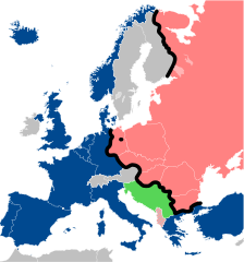
Grandezo di la previdado PNG de ica arkivo SVG: 560 x 599 pixels. Altra qualeso, en pixel-i: 224 x 240 pixels | 449 x 480 pixels | 718 x 768 pixels | 957 x 1 024 pixels | 1 914 x 2 048 pixels | 645 x 690 pixels.
Arkivo originala (arkivo SVG, nominale 645 x 690 "pixels", kun 322 KB)
Titulo
| Deskripto |
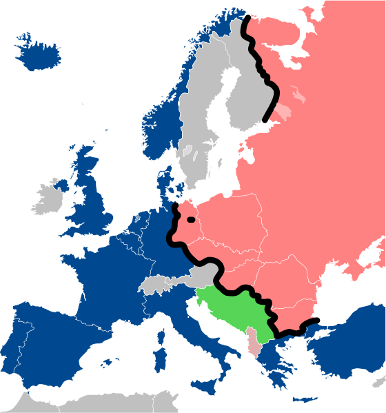
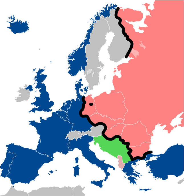
Lëtzebuergesch: Kaart vum Westen an dem Ostblock an Europa während dem Kale Krich.
"Eise Rido"
Neutral Länner
|
||
| Dato | |||
| Fonto |
Travail personnel (own work). Sources:
|
||
| Autoro | Sémhur | ||
| Altra versioni |
File:Iron Curtain map alternative.svg (Same, but with Yugoslavia on the Eastern side of the Iron Curtain.) | ||
| Atribuo (required by the license) | © Sémhur / Wikimedia Commons / | ||
| SVG | W3C-validity not checked.
|
||
| Graphic Lab |

| Pozicio de la fotilo | | Tiu cxi bildo kaj pliaj sur OpenStreetMap |
|---|
Licencizo
Me, la proprietero dil autoroyuri pri ica verko, per to publikigos ol segun la sequanta yurizi:
| Kopiyuro ("Copyleft"): Ita arto-verko es libera; vu povas distributar ed/od modifikar ol segun la kondicioni dil Licenco Libera Arto. Vu povas trovar specimeno di ta licenco ye la loko Copyleft Attitude ed anke ye altra loki. |
This file is licensed under the Creative Commons Attribution-Share Alike 4.0 International, 3.0 Unported, 2.5 Generic, 2.0 Generic and 1.0 Generic license.
- Vu povas:
- partigar – kopiar, distributar e transsendar la verko
- Mixar – adaptar l'arkivo
- Segun la sequanta kondicioni:
- Atribuo – Vu mustas referar l'artiklo o verko segun la formo definita dal autoro o dal proprietero dil autoroyuro, ed informar se modifikuri facesis. Vu mustas facar to per justa formo, ma ne insinuar ke l'autoro konfidis ol a vu, od aprobis vua uzo dil artiklo.
- partigar identa ('share alike') – Se vu modifikos, transformos od augmentos ica verko, vu mustos distributar la rezulto segun la sama, o simila licenco, quale l'originalo.
Selektez l'yurizo quon vu preferas.
Historio dil arkivo
Kliktez sur la dato/horo por vidar arkivo quale ol aparis ye ta tempo.
| Dato/Horo | Miniaturo | Dimensioni | Uzero | Komento | |
|---|---|---|---|---|---|
| aktuala | 13:26, 15 dec. 2022 | | 645 × 690 (322 KB) | PhotographyEdits | Extend the Iron Curtain eastwards of Yugoslavia. Even though Yugoslavia was not really considered part of the West, the currenet map gives the false impression that there was a huge gap in the Iron Curtain, which wasn't the case. |
| 00:56, 23 jul. 2022 |  | 645 × 690 (321 KB) | Kwamikagami | NATO blue, #004990 | |
| 20:30, 30 mar. 2019 |  | 645 × 690 (321 KB) | Sémhur | Reverted to version as of 07:07, 27 May 2014 (UTC). Albania leaves the Waras Pack in middle of cold war; this is why it's shown wtih stripes. | |
| 09:18, 24 mar. 2019 |  | 512 × 548 (123 KB) | Hakuli | Albania leaves the Waras Pack in middle of cold war | |
| 07:07, 27 may. 2014 |  | 645 × 690 (321 KB) | Sémhur | Valid SVG | |
| 13:51, 16 nov. 2010 |  | 645 × 690 (321 KB) | Sémhur | Added Iron Curtain between Bulgaria and Greece & Turkey. | |
| 16:57, 27 sep. 2008 |  | 645 × 690 (321 KB) | Sémhur | Correcting mistake : Austria wasn't in NATO. | |
| 10:51, 31 may. 2008 |  | 645 × 690 (330 KB) | Sémhur | {{Information |Description={{en|1=Map of the Iron Curtain in Europe.}} {{fr|1=Carte du rideau de fer en Europe.}} {{es|1=Mapa del Telón de Acero en Europa.}} |Source=Travail personnel (ow |
Ligilo al imajo
Ca pagini ligas al imajo:
Uzado en altra Wiki
La sequanta Wiki anke uzas ica arkivo:
- Uzado en af.wikipedia.org
- Uzado en als.wikipedia.org
- Uzado en ar.wikipedia.org
- Uzado en ast.wikipedia.org
- Uzado en azb.wikipedia.org
- Uzado en az.wikipedia.org
- Uzado en ba.wikipedia.org
- Uzado en be-tarask.wikipedia.org
- Uzado en be.wikipedia.org
- Uzado en bg.wikipedia.org
- Uzado en br.wikipedia.org
- Uzado en bs.wikipedia.org
- Uzado en ca.wikipedia.org
- Uzado en cs.wikipedia.org
- Uzado en cy.wikipedia.org
- Uzado en da.wikipedia.org
- Uzado en de.wikipedia.org
- Uzado en el.wikipedia.org
- Uzado en el.wiktionary.org
- Uzado en en.wikipedia.org
- Uzado en en.wikibooks.org
- Uzado en en.wikiquote.org
- Uzado en en.wiktionary.org
Videz altra uzadi por ica artiklo.