
Arkivo:Kazakhstan location map.svg

Arkivo originala (arkivo SVG, nominale 1 984 x 1 134 "pixels", kun 634 KB)
Titulo
| Deskripto |
Deutsch: Positionskarte von Kasachstan
Quadratische Plattkarte, N-S-Streckung 150 %. Geographische Begrenzung der Karte:
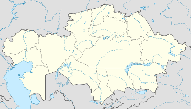
English: Location map of Kazakhstan
Equirectangular projection, N/S stretching 150 %. Geographic limits of the map:
|
|
| Dato | ||
| Fonto |
Propra verko, using
|
|
| Autoro | NordNordWest | |
| Yurizo (Riuzo di ica arkivo) |
Ca arkivo licencesis sub licenco Creative Commons Attribution-Share Alike 3.0 Germania.
 Ca arkivo licencesis sub licenco Creative Commons Attribution-Share Alike 3.0 Germania.
|


|
This map has been made or improved in the German Kartenwerkstatt (Map Lab). You can propose maps to improve as well.
|
Historio dil arkivo
Kliktez sur la dato/horo por vidar arkivo quale ol aparis ye ta tempo.
| Dato/Horo | Miniaturo | Dimensioni | Uzero | Komento | |
|---|---|---|---|---|---|
| aktuala | 18:48, 1 di agosto. 2010 | | 1 984 × 1 134 (634 KB) | NordNordWest | upd |
| 19:15, 27 nov. 2009 |  | 1 985 × 1 134 (949 KB) | NordNordWest | c | |
| 12:42, 24 nov. 2009 |  | 1 984 × 1 134 (942 KB) | NordNordWest | c | |
| 12:38, 24 nov. 2009 |  | 1 985 × 1 134 (941 KB) | NordNordWest | ||
| 18:41, 23 nov. 2009 |  | 1 985 × 1 134 (516 KB) | NordNordWest | =={{int:filedesc}}== {{Information |Description= {{de|Positionskarte von Kasachstan, '''Vorversion'''}} Quadratische Plattkarte, N-S-Streckung 150 %. Geographische Begrenzung der Karte: * N: 56° N * S: 40° N * W: 46° O * O: 88° O {{ |
Ligilo al imajo
Nula pagino ligesas ad ica pagino.
Uzado en altra Wiki
La sequanta Wiki anke uzas ica arkivo:
- Uzado en av.wikipedia.org
- Uzado en bg.wikinews.org
- Uzado en de.wikipedia.org
- Uzado en es.wikipedia.org
- Uzado en fr.wikipedia.org
- Uzado en incubator.wikimedia.org
- Uzado en kaa.wikipedia.org
- Uzado en lv.wikipedia.org
- Uzado en mt.wikipedia.org
- Uzado en pt.wikipedia.org
- Uzado en rue.wikipedia.org
- Uzado en ru.wikipedia.org
- Uzado en sk.wikipedia.org