
Arkivo:Partition of Hungary.png
Ne existas grandeso plu granda.
Partition_of_Hungary.png (389 × 328 pixel-i, grandeso dil arkivo: 31 KB, MIME type: image/png)
Titulo

| Deskripto |
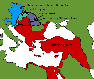
A map displaying position of the Kingdom of Hungary before 1541, and the 3 parts into which it was divided after the occupation of Buda in 1541: Royal Hungary, Eastern Hungarian kingdom, and the part that was annexed by the Ottoman Empire. en:Category:Maps of the history of Hungary |
| Dato | la 3-a de septembro 2006 (origina alŝuta dato) |
| Fonto | Transigita de en.wikipedia al Commons. |
| Autoro | Later versions were uploaded by PANONIAN, DonatusHR at en.wikipedia. |
Licencizo
| Ĉi tiu verko estis liberigita kiel publika havaĵo de ties aŭtoro, Esoltas de angla Wikipedio. Tio aplikatas tutmonde. In alcuni paesi questo atto potrebbe non essere riconosciuto valido dalla locale normativa; in tal caso: Esoltas donas al iu ajn la rajton uzi ĉi tiun verkon por iu ajn uzo, sen kondiĉoj, krom se tiuj kondiĉoj deviĝas per leĝo. |
Originala protokolo dum sendado dil arkivo
The original description page was here. All following user names refer to en.wikipedia.
- 2007-08-12 15:14 DonatusHR 389×328×8 (38357 bytes) Vraćeno na prijašnju inačicu
- 2007-08-12 15:13 DonatusHR 389×328×8 (35596 bytes) Vraćeno na prijašnju inačicu
- 2006-10-11 10:58 PANONIAN 389×328×8 (38357 bytes) corrected image
- 2006-09-03 15:00 Esoltas 389×328×8 (35596 bytes) A map displaying the original position of the Kingdom of Hungary, and the 3 lands that became of it after the Battle of Mohács: Royal Hungary, Transylvania, and the Ottoman-occupied section.
Historio dil arkivo
Kliktez sur la dato/horo por vidar arkivo quale ol aparis ye ta tempo.
| Dato/Horo | Miniaturo | Dimensioni | Uzero | Komento | |
|---|---|---|---|---|---|
| aktuala | 17:22, 12 feb. 2016 | | 389 × 328 (31 KB) | Packare | better caption |
| 17:58, 10 sep. 2007 |  | 389 × 328 (37 KB) | Sir Iain | {{Information |Description=A map displaying position of the Kingdom of Hungary before 1526, and the 3 parts into which it was divided after the Battle of Mohács: Royal Hungary, Transylvania, and the part that was annexed by the Ottoman Empire. [[:en:Ca |
Ligilo al imajo
Ca pagini ligas al imajo:
Uzado en altra Wiki
La sequanta Wiki anke uzas ica arkivo:
- Uzado en ar.wikipedia.org
- Uzado en azb.wikipedia.org
- Uzado en de.wikipedia.org
- Uzado en el.wikipedia.org
- Uzado en en.wikipedia.org
- Uzado en es.wikipedia.org
- Uzado en fr.wikipedia.org
- Uzado en gl.wikipedia.org
- Uzado en hu.wikipedia.org
- Uzado en it.wikipedia.org
- Uzado en ja.wikipedia.org
- Uzado en ko.wikipedia.org
- Uzado en lv.wikipedia.org
- Uzado en nl.wikipedia.org
- Uzado en sk.wikipedia.org
- Uzado en trv.wikipedia.org
- Uzado en tr.wikipedia.org
- Uzado en uk.wikipedia.org
- Uzado en uz.wikipedia.org
- Uzado en zh.wikipedia.org