
Arkivo:Slave and Free States before the American Civil War.svg

Grandezo di la previdado PNG de ica arkivo SVG: 800 x 502 pixels. Altra qualeso, en pixel-i: 320 x 201 pixels | 640 x 401 pixels | 1 024 x 642 pixels | 1 280 x 803 pixels | 2 560 x 1 605 pixels | 882 x 553 pixels.
Arkivo originala (arkivo SVG, nominale 882 x 553 "pixels", kun 105 KB)
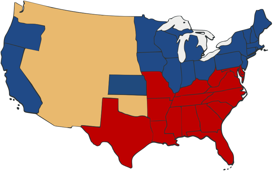
| Deskripto | Free and Slave States in the period leading to the American Civil War. Free states are blue, slave states in red. Territories are a neutral yellow. | ||
| Dato | |||
| Fonto | Based on Image:US_Secession_map_1865.svg with information from en:Image:Freeandslavestates.gif | ||
| Autoro | Self-made from public domain work Image:US_Secession_map_1865.svg | ||
| Yurizo (Riuzo di ica arkivo) |
|
||
| Altra versioni |
 |
Historio dil arkivo
Kliktez sur la dato/horo por vidar arkivo quale ol aparis ye ta tempo.
| Dato/Horo | Miniaturo | Dimensioni | Uzero | Komento | |
|---|---|---|---|---|---|
| aktuala | 23:05, 27 sep. 2007 | | 882 × 553 (105 KB) | Adam Cuerden | Fixed the borders in th e territories by muckin' 'em around. |
| 22:59, 27 sep. 2007 |  | 882 × 553 (104 KB) | Adam Cuerden | {{Information |Description= |Source= Based on Image:US_Secession_map_1865.svg with information from en:Image:Freeandslavestates.gif |Date=2007 |Author=Self-made from public domain work Image:US_Secession_map_1865.svg |Permission={{PD-retouc |
Ligilo al imajo
Ca pagini ligas al imajo:
Uzado en altra Wiki
La sequanta Wiki anke uzas ica arkivo:
- Uzado en de.wikipedia.org
- Uzado en en.wikipedia.org
- Uzado en fr.wikipedia.org
- Uzado en it.wikipedia.org
- Uzado en la.wikipedia.org
- Uzado en no.wikipedia.org
- Uzado en pl.wikipedia.org