
Arkivo:US-IN-Gary.png

Grandeso de ica previdado: 384 x 600 pixels. Altra qualeso, en pixel-i: 153 x 240 pixels | 512 x 800 pixels.
Arkivo originala (512 × 800 pixel-i, grandeso dil arkivo: 33 KB, MIME type: image/png)
Titulo
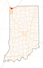
| Deskripto | Red Dot map of Indiana, showing the location of Gary |
| Dato | (UTC) |
| Fonto | Self-made with a custom-made GIS application from public data sources |
| Autoro | Sean Baker ( Marvin01 | talk ) |
| Yurizo (Riuzo di ica arkivo) |
Free use, with attribution, under the Cc-by-2.0 license (see below). If you copy this image to modify it for another purpose, please respect the terms of this license and add a link back to the original image on the description page, or contact me to waive this restriction. |
| Altra versioni | none |
Licencizo
Ica arkivo havas la permiso Creative Commons Attribution 2.0 Generic.
- Vu povas:
- partigar – kopiar, distributar e transsendar la verko
- Mixar – adaptar l'arkivo
- Segun la sequanta kondicioni:
- Atribuo – Vu mustas referar l'artiklo o verko segun la formo definita dal autoro o dal proprietero dil autoroyuro, ed informar se modifikuri facesis. Vu mustas facar to per justa formo, ma ne insinuar ke l'autoro konfidis ol a vu, od aprobis vua uzo dil artiklo.
Historio dil arkivo
Kliktez sur la dato/horo por vidar arkivo quale ol aparis ye ta tempo.
| Dato/Horo | Miniaturo | Dimensioni | Uzero | Komento | |
|---|---|---|---|---|---|
| aktuala | 06:53, 22 okt. 2005 | | 512 × 800 (33 KB) | Marvin01 | {{User:Marvin01/Template:US-IN-Information|city=Gary|date=~~~~~}} Category:Locator_maps_of_cities_in_Indiana |
| 20:16, 19 okt. 2005 |  | 256 × 400 (13 KB) | Marvin01 | {{User:Marvin01/Template:US-IN-Information|city=Gary|date=~~~~~}} |
Ligilo al imajo
Ca pagini ligas al imajo:
Uzado en altra Wiki
La sequanta Wiki anke uzas ica arkivo:
- Uzado en cs.wikipedia.org
- Uzado en da.wikipedia.org
- Uzado en nl.wikipedia.org