
Arkivo:1850 IC.jpg

Arkivo originala (3 536 × 5 856 pixel-i, grandeso dil arkivo: 2,99 MB, MIME type: image/jpeg)
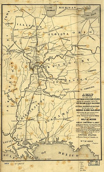
1850 map of the Illinois Central Railroad and New Orleans and Ohio Railroad (which became part of the IC) from [1]. Also shows the Mobile and Ohio Railroad, later part of the Gulf, Mobile and Ohio Railroad. Also shows the proposed "Western District of Columbia" where the two lines would meet, including Metropolis, Illinois and the never-built Capitol City, Kentucky.
|
Tiu ĉi verko estas publika havaĵo en tiuj landoj, kies kopirajtado validas por longo de vivo plus 70 jaroj aŭ malpli.
| |
| Questo file è stato riconosciuto come libero da restrizioni di cui si abbia contezza ai sensi della normativa sul diritto d'autore, inclusi tutti i diritti annessi e connessi. | |
Historio dil arkivo
Kliktez sur la dato/horo por vidar arkivo quale ol aparis ye ta tempo.
| Dato/Horo | Miniaturo | Dimensioni | Uzero | Komento | |
|---|---|---|---|---|---|
| aktuala | 12:13, 26 di agosto. 2005 | | 3 536 × 5 856 (2,99 MB) | SPUI~commonswiki | {{PD}} 1850 map of the Illinois Central Railroad and New Orleans and Ohio Railroad (which became part of the IC) from [http://memory.loc.gov/cgi-bin/query/r?ammem/gmd:@field(NUMBER+@band(g4041p+rr004740))]. Also shows the Mobile and Ohio Railroad, later p |
Ligilo al imajo
Nula pagino ligesas ad ica pagino.
Uzado en altra Wiki
La sequanta Wiki anke uzas ica arkivo:
- Uzado en de.wikipedia.org
- Uzado en en.wikipedia.org
- Uzado en eo.wikipedia.org
- Uzado en ja.wikipedia.org
- Uzado en zh.wikipedia.org