
Arkivo:Italy 1000 AD-it.svg

Grandezo di la previdado PNG de ica arkivo SVG: 418 x 600 pixels. Altra qualeso, en pixel-i: 167 x 240 pixels | 334 x 480 pixels | 535 x 768 pixels | 713 x 1 024 pixels | 1 427 x 2 048 pixels | 565 x 811 pixels.
Arkivo originala (arkivo SVG, nominale 565 x 811 "pixels", kun 400 KB)
Titulo
| Deskripto |
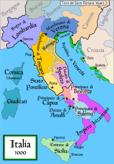
English: Political map of Italy in 1000 AD (CE).
Italiano: Mappa politica dell'Italia nel 1000. |
| Fonto | Propra verko |
| Autoro | MapMaster |
| Altra versioni |
[]
SVG:
PNG:
|


|
This SVG file contains embedded text that can be translated into your language, using any capable SVG editor, text editor or the SVG Translate tool. For more information see: About translating SVG files. |
References
- Bjorklund, Oddvar; Holmboe, Haakon; Rohr, Anders (1970) Historical Atlas of the World, Barnes & Noble, NY, SBN: 389-00253-4.
- This map from Allyn & Bacon, Longman, textbook publishers.
- This map of the w:en:Holy Roman Empire
- A map from Attilios
- This map of 1050 AD Italy, from the 1923 The Historical Atlas by William R. Shepherd
- This map of 1000 AD Italy from Fordham University, adapted from Muir's Historical Atlas, (1911).
In addition, a number of other sources were consulted in an effort to determine the following matters:
- The extent of Venetian control over the cities of Dalmatia such as Zara and Spalato. Although the Venetians had been pushed off the mainland earlier, in the period around the year 1000, the Venetians made an effort to recover these cities.
- The extent of Saracen control over Corsica and Sardinia. Information is sparse. The apparent situation is that the Muslims had several bases on the coasts of these islands, but did not control the countryside (such as they did in Sicily).
- Whether or not the principalities of Capua and Benevento were separate states in the year 1000. Based on lists of their rulers (various Pandulfs and Landulfs), the answer seems to be "yes".
- Who controlled the Balkans on the southeastern border of the Kingdom of Croatia. Candidates include Bulgaria, the Byzantine Empire, Croatia, and Serbia.
As noted, there is significant disagreement among sources on these questions.
This map was commissioned by Attilios, and there is also a discussion to be found on MapMaster's English talk page.
Licencizo
Me, la posedanto dil autoroyuro pri ica imajo/arkivo, permisos lua uzado camaniere:

|
On darfas kopiigar, distributar ed/od altrigar ica dokumento segun la kondicioni di GNU Free Documentation License, quale esas mencionita en la versiono 1.2 od en irga plu posa versiono, qua esas publikigita da Free Software Foundation; En la dokumento ne darfas esas ne-altrigita parti ed olu ne darfas esar kom texto di frontala o dopala pagino di libro o GNU Free Documentation License. |
| Ica arkivo liberigesas sub permiso Creative Commons Attribution-Share Alike 3.0 Unported. | ||
| ||
| Ica etiketo pri uzo-permiso ligesis ad ica artiklo dum l'aktualigo dil yurizo GFDL. |
Historio dil arkivo
Kliktez sur la dato/horo por vidar arkivo quale ol aparis ye ta tempo.
| Dato/Horo | Miniaturo | Dimensioni | Uzero | Komento | |
|---|---|---|---|---|---|
| aktuala | 05:48, 24 apr. 2012 | | 565 × 811 (400 KB) | ANGELUS | fixed |
| 05:40, 24 apr. 2012 |  | 565 × 811 (395 KB) | ANGELUS | micro fix | |
| 18:26, 28 may. 2010 |  | 565 × 811 (399 KB) | Vajotwo | Updated | |
| 17:54, 14 dec. 2007 |  | 565 × 811 (407 KB) | Salli~commonswiki | ||
| 03:45, 21 feb. 2007 |  | 565 × 811 (694 KB) | MapMaster | Minor fixes, in an attempt to align with other Italia maps. | |
| 18:28, 2 feb. 2007 |  | 565 × 811 (694 KB) | MapMaster | small fixes per it:Discussioni utente:MapMaster#Maps of Italy. | |
| 22:15, 27 jan. 2007 |  | 565 × 811 (689 KB) | MapMaster | Italia |
Ligilo al imajo
Nula pagino ligesas ad ica pagino.
Uzado en altra Wiki
La sequanta Wiki anke uzas ica arkivo:
- Uzado en azb.wikipedia.org
- Uzado en bg.wikipedia.org
- Uzado en br.wikipedia.org
- Uzado en cs.wikipedia.org
- Uzado en de.wikipedia.org
- Uzado en en.wikipedia.org
- Uzado en gl.wikipedia.org
- Uzado en hr.wikipedia.org
- Uzado en it.wikipedia.org
- Veneto
- Antichi Stati italiani
- Papa Benedetto VIII
- Storia della Sicilia islamica
- Discussioni portale:Storia
- Ducato di Spoleto
- Storia di Pisa
- Principi di Salerno
- Kalbiti
- Obertenghi
- Utente:MapMaster
- Principato di Capua
- Emirato
- Storia di Amalfi
- Alto Medioevo
- Storia di Venezia
- Rinascita dell'anno Mille
- Italiani
- Venezia
- Storia di Verona
- Utente:Tizio X/Sandbox3
- Storia di Monteleone d'Orvieto
- Storia d'Italia
- Dialetti galloitalici di Sicilia
- Battaglia di Capo Colonna
- Storia del Veneto
- Utente:Fabiodevivo/Sandbox
- Guerre arabo-bizantine
- Storia della Romagna
- Marca di Tuscia
- Abū l-Qāsim al-Hasan
- Storia della Repubblica di Venezia
- Guerre bizantino-normanne
- Abu l-Qasim Ali
- Storia di Pescara
- Storia dell'islam nell'Italia medievale
- Discussione:Storia d'Italia/Sandbox
- Este
Videz altra uzadi por ica artiklo.