Irez a kontenajo

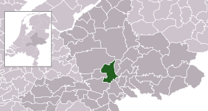
Arkivo:Map - NL - Municipality code 0202 (2009).svg

Paĝenhavo ne ekzistas en aliaj lingvoj.
De Wikipedio

Arkivo originala (arkivo SVG, nominale 300 x 160 "pixels", kun 530 KB)

Ca arkivo jacas en Wikimedia Commons, e povas uzesar en altra projeti. La deskriptado en lua pagino di deskriptado montresas adinfre.

Deskripto
  • Location maps for the 441 municipalities in the Netherlands. Boundaries 1/1/2009
  • Automatically generated with script
  • File name contains "Municipality code" (CBS-code) as specified in: [1]
  • Created in svg using coordinate data derived from ESRI data published by Centraal Bureau voor de Statistiek, Voorburg/Heerlen. ([2])
  • Color coding and original design (slightly adpated by me) by user Mtcv (2006/2007) ([3])


© La posedanto de la aŭtorrajto por ĉi tiu dosiero, Centraal Bureau voor de Statistiek, permesas al ĉiu ajn utiligi ĝin por ia ajn kialo, se la posedanto de la aŭtorrajto estas bone atributita. Redistribuado, deriva verkado, komerca uzado, kaj ĉiuj aliaj uzoj estas permesitaj.

This image is (in part or entirely) based on geographical data from Statistics Netherlands (Centraal Bureau voor de Statistiek). Digital geometry files in ESRI format can be downloaded from their website [4].

In particular, boundary data of statistical districts is based on either the Wijk- en buurtkaart 2005, or the Wijk- en buurtkaart 2003 ("CBS/TOPgrenzen"). Data on localities (bevolkingskernen) are from the publication Bevolkingskernen in Nederland 2001.

Conditions of use (in Dutch):

  • Bij visualisering van gegevens met behulp van het digitale bestand Wijk- en buurtkaart 2005 dient te worden vermeld:
Bron: © 2006, Centraal Bureau voor de Statistiek / Topografische Dienst Kadaster
  • Bij visualisering van gegevens met behulp van het digitale bestand CBS/TOPgrenzen dient te worden vermeld:
Grenzen ondergrond: © 2003, Centraal Bureau voor de Statistiek/Topografische Dienst Kadaster
  • Bij visualisering van gegevens met behulp van het digitale bestand "Bevolkingskernen 2001" dient te worden vermeld:
Bron: © 2005, Centraal Bureau voor de Statistiek

Unless otherwise specified, data on waterways and lakes are from the public domain Digital Chart of the World.

Dato
Fonto own work , using CBS data
Autoro Michiel1972 (talk) 21:58, 24 January 2009 (UTC)
Yurizo
(Riuzo di ica arkivo)
Attribution ShareAlike 3.0
w:eo:Creative Commons
Atribuo partigar identa ('share alike')
Ica arkivo liberigesas sub permiso Creative Commons Attribution-Share Alike 3.0 Unported.
Vu povas:
  • partigar – kopiar, distributar e transsendar la verko
  • Mixar – adaptar l'arkivo
Segun la sequanta kondicioni:
  • Atribuo – Vu mustas referar l'artiklo o verko segun la formo definita dal autoro o dal proprietero dil autoroyuro, ed informar se modifikuri facesis. Vu mustas facar to per justa formo, ma ne insinuar ke l'autoro konfidis ol a vu, od aprobis vua uzo dil artiklo.
  • partigar identa ('share alike') – Se vu modifikos, transformos od augmentos ica verko, vu mustos distributar la rezulto segun la sama, o simila licenco, quale l'originalo.

Titoloj

Adjuntez 1 lineo explikanta quo reprezentas ca arkivo

Kozi montrata en ca arkivo

montras Esperanto

januaro 2009

Historio dil arkivo

Kliktez sur la dato/horo por vidar arkivo quale ol aparis ye ta tempo.

Dato/HoroMiniaturoDimensioniUzeroKomento
aktuala21:58, 24 jan. 2009Imajeto di versiono ye 21:58, 24 jan. 2009300 × 160 (530 KB)Michiel1972{{Information |Description=*Location maps for the 441 municipalities in the Netherlands. Boundaries 1/1/2009 *Automatically generated with script *File name contains "Municipality code" (CBS-code) as specified in: [http://www.cbs.nl/nl-NL/menu/methoden/c

Ca pagini ligas al imajo:

Uzado en altra Wiki

La sequanta Wiki anke uzas ica arkivo:

Metadonaji