
Arkivo:Occupied Palestinian Territories.jpg

Grandeso de ica previdado: 393 x 599 pixels. Altra qualeso, en pixel-i: 157 x 240 pixels | 315 x 480 pixels | 504 x 768 pixels | 672 x 1 024 pixels | 1 895 x 2 889 pixels.
Arkivo originala (1 895 × 2 889 pixel-i, grandeso dil arkivo: 949 KB, MIME type: image/jpeg)
Titulo
| Deskripto |
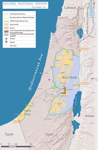
English: Map of the Occupied Palestinian Territories (West Bank and Gaza Strip), marked by the Green Line. Based on Reference Map: occupied Palestinian territory: Overview Map, as of December 2011. Published by United Nations Office for the Coordination of Humanitarian Affairs (OCHAoPt), 25 January 2012
العربية: خريطة للأراضي الفلسطينية المحتلة (الضفة الغربية وقطاع غزة) ، مميزة بالخط الأخضر. استنادًا إلى الخريطة المرجعية: "الأراضي الفلسطينية المحتلة: خريطة عامة" ، اعتبارًا من ديسمبر 2011. تم النشر بواسطة مكتب الأمم المتحدة لتنسيق الشؤون الإنسانية (OCHAoPt ) ، 25 يناير 2012 |
| Dato | |
| Fonto | Propra verko, based on http://www.ochaopt.org/documents/ochaopt_atlas_opt_general_december2011.pdf on [1] |
| Autoro | Wickey-nl |

|
Tiu ĉi bildo map respektive ĉiuj bildoj en tiu ĉi artikolo aŭ kategorio prefere estu rekreata(j) kiel vektora grafikaĵo en la formato SVG. Vektoraj formatoj por grafikaĵoj havas multajn avantaĝojn, detaloj troveblas anglalingve en la komuneja artikolo Commons:Media for cleanup. Se vi havas aŭ kreas SVG-version de tiu ĉi bildo, bonvolu alŝuti ĝin al la vikipedia komunejo. Post tiu ago, ĉi tiu ŝablono en la bildpaĝo estas anstataŭigenda per la ŝablono {{vector version available|nova dosiera nomo.svg}}.
|


Licencizo
Me, la posedanto dil autoroyuro pri ica imajo/arkivo, permisos lua uzado camaniere:
Ica arkivo liberigesas sub permiso Creative Commons Attribution-Share Alike 3.0 Unported.
- Vu povas:
- partigar – kopiar, distributar e transsendar la verko
- Mixar – adaptar l'arkivo
- Segun la sequanta kondicioni:
- Atribuo – Vu mustas referar l'artiklo o verko segun la formo definita dal autoro o dal proprietero dil autoroyuro, ed informar se modifikuri facesis. Vu mustas facar to per justa formo, ma ne insinuar ke l'autoro konfidis ol a vu, od aprobis vua uzo dil artiklo.
- partigar identa ('share alike') – Se vu modifikos, transformos od augmentos ica verko, vu mustos distributar la rezulto segun la sama, o simila licenco, quale l'originalo.

Historio dil arkivo
Kliktez sur la dato/horo por vidar arkivo quale ol aparis ye ta tempo.
| Dato/Horo | Miniaturo | Dimensioni | Uzero | Komento | |
|---|---|---|---|---|---|
| aktuala | 17:08, 25 mar. 2014 | | 1 895 × 2 889 (949 KB) | Wickey-nl | User created page with UploadWizard |
Ligilo al imajo
Ca pagini ligas al imajo:
Uzado en altra Wiki
La sequanta Wiki anke uzas ica arkivo:
- Uzado en af.wikipedia.org
- Uzado en ar.wikipedia.org
- Uzado en az.wikipedia.org
- Uzado en bh.wikipedia.org
- Uzado en bn.wikipedia.org
- Uzado en bug.wikipedia.org
- Uzado en cs.wikipedia.org
- Uzado en da.wikipedia.org
- Uzado en de.wikipedia.org
- Uzado en el.wikipedia.org
- Uzado en en.wikipedia.org
- Israeli–Palestinian conflict
- Palestinian territories
- Israeli-occupied territories
- Frozen conflict
- United Nations Security Council Resolution 1515
- Talk:Israeli–Palestinian conflict/Archive 18
- United States involvement in regime change
- Boycott, Divestment and Sanctions
- Two-state solution
- Talk:State of Palestine/Archive 12
- Freedom of religion in Asia by country
- User:Falcaorib
- From the river to the sea
- User:Christophervincent01
- Uzado en es.wikipedia.org
- Uzado en et.wikipedia.org
- Uzado en fa.wikipedia.org
- Uzado en fi.wikipedia.org
- Uzado en fy.wikipedia.org
- Uzado en gl.wikipedia.org
- Uzado en he.wikipedia.org
- Uzado en hu.wikipedia.org
- Uzado en id.wikipedia.org
- Uzado en it.wikipedia.org
- Uzado en ja.wikipedia.org
- Uzado en la.wikipedia.org
- Uzado en lt.wikipedia.org
Videz altra uzadi por ica artiklo.