Arkivo:PalestineAndTransjordan.png

Paĝenhavo ne ekzistas en aliaj lingvoj.
De Wikipedio

PalestineAndTransjordan.png(636 × 599 pixel-i, grandeso dil arkivo: 65 KB, MIME type: image/png)

Ca arkivo jacas en Wikimedia Commons, e povas uzesar en altra projeti. La deskriptado en lua pagino di deskriptado montresas adinfre.

File:PalestineAndTransjordan.svg esas vektorala versiono de ca imajo. Ol mustas uzesar vice la nuna imajo, se ol ne havas inferiora qualeso.

File:PalestineAndTransjordan.png → File:PalestineAndTransjordan.svg

Por plusa informo, videz Ajuda:SVG.

Em outras línguas
Alemannisch  Bahasa Indonesia  Bahasa Melayu  British English  català  čeština  dansk  Deutsch  eesti  English  español  Esperanto  euskara  français  Frysk  galego  hrvatski  Ido  italiano  lietuvių  magyar  Nederlands  norsk bokmål  norsk nynorsk  occitan  Plattdüütsch  polski  português  português do Brasil  română  Scots  sicilianu  slovenčina  slovenščina  suomi  svenska  Tiếng Việt  Türkçe  vèneto  Ελληνικά  беларуская (тарашкевіца)  български  македонски  нохчийн  русский  српски / srpski  татарча/tatarça  українська  ქართული  հայերեն  বাংলা  தமிழ்  മലയാളം  ไทย  한국어  日本語  简体中文  繁體中文  עברית  العربية  فارسی  +/−
Nova imagem SVG

Deskripto
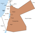
English: Map of the British Mandate of Palestine and Transjordan.
Note: Wasserstein, Bernard (2004). Israel and Palestine: Why They Fight and Can They Stop?, pp. 105–106."Palestine, therefore, was not partitioned in 1921–1922. Transjordan was not excised but, on the contrary, added to the mandatory area. Zionism was barred from seeking to expand there – but the Balfour Declaration had never previously applied to the area east of the Jordan. Why is this important? Because the myth of Palestine's 'first partition' has become part of the concept of 'Greater Israel' and of the ideology of Jabotinsky's Revisionist movement."
Fonto

Originally uploaded on the English Wiki (all linking to en.wikipedia):

08:13, 8 June 2005 Doron (Talk / contribs) uploaded "Image:PalestineAndTransjordan.png"
Autoro User:Doron
Yurizo
(Riuzo di ica arkivo)
GNU head On darfas kopiigar, distributar ed/od altrigar ica dokumento segun la kondicioni di GNU Free Documentation License, quale esas mencionita en la versiono 1.2 od en irga plu posa versiono, qua esas publikigita da Free Software Foundation; En la dokumento ne darfas esas ne-altrigita parti ed olu ne darfas esar kom texto di frontala o dopala pagino di libro o GNU Free Documentation License.
w:eo:Creative Commons
Atribuo partigar identa ('share alike')
Ica arkivo liberigesas sub permiso Creative Commons Attribution-Share Alike 3.0 Unported.
Vu povas:
  • partigar – kopiar, distributar e transsendar la verko
  • Mixar – adaptar l'arkivo
Segun la sequanta kondicioni:
  • Atribuo – Vu mustas referar l'artiklo o verko segun la formo definita dal autoro o dal proprietero dil autoroyuro, ed informar se modifikuri facesis. Vu mustas facar to per justa formo, ma ne insinuar ke l'autoro konfidis ol a vu, od aprobis vua uzo dil artiklo.
  • partigar identa ('share alike') – Se vu modifikos, transformos od augmentos ica verko, vu mustos distributar la rezulto segun la sama, o simila licenco, quale l'originalo.
Ica etiketo pri uzo-permiso ligesis ad ica artiklo dum l'aktualigo dil yurizo GFDL.
Altra versioni Image:BritishMandatePalestine1920.png

Titoloj

Adjuntez 1 lineo explikanta quo reprezentas ca arkivo

Kozi montrata en ca arkivo

montras Esperanto

sub kopirajto Esperanto

Historio dil arkivo

Kliktez sur la dato/horo por vidar arkivo quale ol aparis ye ta tempo.

Dato/HoroMiniaturoDimensioniUzeroKomento
aktuala15:17, 22 mar. 2019Imajeto di versiono ye 15:17, 22 mar. 2019636 × 599 (65 KB)Claude ZygielThis file in clearly definite as "Map of the British Mandate of Palestine '''and''' Transjordan" and used for the both territories
12:01, 24 okt. 2017Imajeto di versiono ye 12:01, 24 okt. 2017636 × 599 (61 KB)Nicola RomaniReverted to version as of 11:02, 22 April 2016 (UTC)
17:04, 30 di agosto. 2017Imajeto di versiono ye 17:04, 30 di agosto. 2017675 × 542 (51 KB)OnceinawhileConverted into new svg - this is the png version
16:07, 19 okt. 2016Imajeto di versiono ye 16:07, 19 okt. 2016636 × 599 (65 KB)Claude ZygielThis file in clearly definite as "Map of the British Mandate of Palestine '''and''' Transjordan" and used for the both territories.
11:02, 22 apr. 2016Imajeto di versiono ye 11:02, 22 apr. 2016636 × 599 (61 KB)Makeandtossoops
11:01, 22 apr. 2016Imajeto di versiono ye 11:01, 22 apr. 2016636 × 599 (61 KB)MakeandtossRemoved Mandatory Palestine since picture is used to refer to only the emirate
15:49, 4 dec. 2011Imajeto di versiono ye 15:49, 4 dec. 2011636 × 599 (66 KB)Wickey-nlthicker lining around lake
21:43, 3 dec. 2011Imajeto di versiono ye 21:43, 3 dec. 2011636 × 599 (66 KB)Wickey-nlFixed border
15:29, 29 jan. 2011Imajeto di versiono ye 15:29, 29 jan. 2011636 × 599 (77 KB)VadacFixed border of Transjordan within the Mandate of Palestine with Saudi Arabia per the present border having been drawn in 1965 as seen here.
11:29, 24 feb. 2006Imajeto di versiono ye 11:29, 24 feb. 2006636 × 599 (89 KB)Lohen11Palestine from:

Nula pagino ligesas ad ica pagino.

Uzado en altra Wiki

La sequanta Wiki anke uzas ica arkivo:

Videz altra uzadi por ica artiklo.

Metadonaji