
Arkivo:River Ostravice (CZE) - location map.svg

Grandezo di la previdado PNG de ica arkivo SVG: 800 x 468 pixels. Altra qualeso, en pixel-i: 320 x 187 pixels | 640 x 374 pixels | 1 024 x 599 pixels | 1 280 x 748 pixels | 2 560 x 1 497 pixels | 5 342 x 3 123 pixels.
Arkivo originala (arkivo SVG, nominale 5 342 x 3 123 "pixels", kun 173 KB)
_-_location_map.svg)
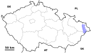
| Deskripto | Location map of the Czech river Ostravice, from its source until its source until it flows into the Oder (magenta) |
| Dato | |
| Fonto | Propra verko |
| Autoro | David Paloch (Caroig) |
| Yurizo (Riuzo di ica arkivo) |
Me, la posedanto dil autoroyuro pri ica imajo/arkivo, permisos lua uzado camaniere: Ĉi tiu dosiero estas disponebla laŭ la permesilo Krea Komunaĵo Atribuite-Samkondiĉe 2.5 Ĝenerala.
|
Historio dil arkivo
Kliktez sur la dato/horo por vidar arkivo quale ol aparis ye ta tempo.
_-_location_map.svg&dir=prev)
_-_location_map.svg&offset=20061225233654)
_-_location_map.svg&offset=&limit=20)
_-_location_map.svg&offset=&limit=50)
_-_location_map.svg&offset=&limit=100)
_-_location_map.svg&offset=&limit=250)
_-_location_map.svg&offset=&limit=500)
| Dato/Horo | Miniaturo | Dimensioni | Uzero | Komento | |
|---|---|---|---|---|---|
| aktuala | 20:59, 11 nov. 2007 | | 5 342 × 3 123 (173 KB) | Caroig | |
| 14:39, 24 mar. 2007 |  | 5 342 × 3 123 (329 KB) | Caroig | missing text | |
| 14:20, 24 mar. 2007 |  | 5 342 × 3 123 (326 KB) | Caroig | Reverted to earlier revision | |
| 14:18, 24 mar. 2007 |  | 5 342 × 3 123 (326 KB) | Caroig | ||
| 14:16, 24 mar. 2007 |  | 5 342 × 3 123 (326 KB) | Caroig | + all rivers | |
| 10:30, 14 jan. 2007 |  | 5 342 × 3 123 (137 KB) | Caroig | even one more version | |
| 10:27, 14 jan. 2007 |  | 5 342 × 3 123 (141 KB) | Caroig | new version with watershed | |
| 13:48, 1 jan. 2007 |  | 3 417 × 1 956 (170 KB) | Caroig | New version | |
| 23:37, 25 dec. 2006 |  | 3 417 × 1 956 (184 KB) | Caroig | {{Information | Description = Location map of the Czech river Ostravice, from its source until its source until it flows into the Oder (magenta) | Source = Own work (using template Image:(CZE)_template_with_map_overlay.svg) | Date = 2006-12-26 | Auth | |
| 23:36, 25 dec. 2006 |  | 3 417 × 1 956 (185 KB) | Caroig | {{Information | Description = Location map of the Czech river Ostravice, from its source until its source until it flows into the Oder (magenta) | Source = Own work (using template Image:(CZE)_template_with_map_overlay.svg) | Date = 2006-12-26 | Auth |
_template_with_map_overlay.svg&action=edit&redlink=1)
Ligilo al imajo
Ca pagini ligas al imajo:
Uzado en altra Wiki
La sequanta Wiki anke uzas ica arkivo:
- Uzado en cs.wikipedia.org
- Uzado en eo.wikipedia.org
- Uzado en es.wikipedia.org
- Uzado en ka.wikipedia.org
- Uzado en nl.wikipedia.org
- Uzado en pl.wikipedia.org
- Uzado en pl.wiktionary.org
- Uzado en ru.wikipedia.org
- Uzado en sk.wikipedia.org
- Uzado en uk.wikipedia.org
_-_location_map.svg)