
Arkivo:Trafalgar 1200hr.gif
Grandeso de ica previdado: 635 x 600 pixels. Altra qualeso, en pixel-i: 254 x 240 pixels | 508 x 480 pixels | 900 x 850 pixels.
Arkivo originala (900 × 850 pixel-i, grandeso dil arkivo: 30 KB, MIME type: image/gif)

|
Ĉi tiu dosiero estas anstataŭigita per File:Trafalgar 1200hr.svg. Prefere uzu tiun alian dosieron. Kialo: The new file is SVG, and has less spelling mistakes
|

|
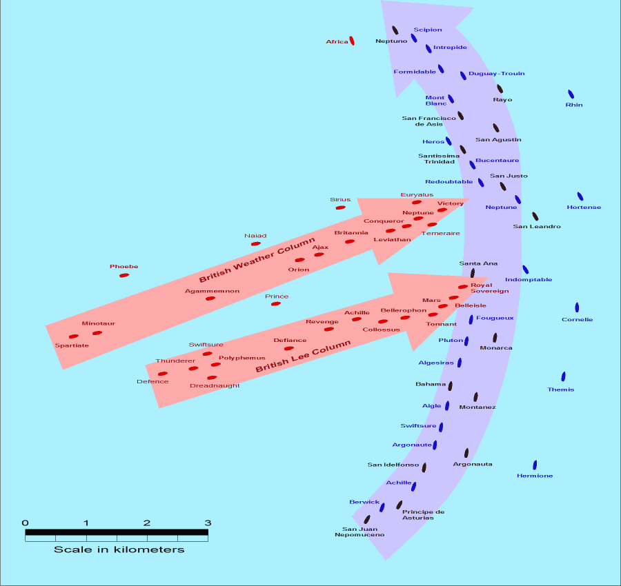
- Description: This map of the Battle of Trafalgar shows the approximate position of the two fleets at 1200 hours during the battle as the Royal Sovereign was breaking into the Franco-Spanish line. North is to the top, and Cape Trafalgar is 10 miles to the northeast.
- Size: 900 × 850 pixels.
- Source: This drawing is based on an illustration in issue number 84 of the Strategy & Tactics magazine The map was made by RJHall using the Campaign Cartographer drawing program, and the image was reduced in size 50% in Paint Shop Pro. Ship icons are not to scale.
Ĉi tiu dosiero estas disponebla laŭ la permesilo Krea Komunaĵo Atribuite-Samkondiĉe 2.5 Ĝenerala.
- Vu povas:
- partigar – kopiar, distributar e transsendar la verko
- Mixar – adaptar l'arkivo
- Segun la sequanta kondicioni:
- Atribuo – Vu mustas referar l'artiklo o verko segun la formo definita dal autoro o dal proprietero dil autoroyuro, ed informar se modifikuri facesis. Vu mustas facar to per justa formo, ma ne insinuar ke l'autoro konfidis ol a vu, od aprobis vua uzo dil artiklo.
- partigar identa ('share alike') – Se vu modifikos, transformos od augmentos ica verko, vu mustos distributar la rezulto segun la sama, o simila licenco, quale l'originalo.
Historio dil arkivo
Kliktez sur la dato/horo por vidar arkivo quale ol aparis ye ta tempo.
| Dato/Horo | Miniaturo | Dimensioni | Uzero | Komento | |
|---|---|---|---|---|---|
| aktuala | 14:30, 28 jul. 2005 | | 900 × 850 (30 KB) | RJHall | Battle of Trafalgar situation at 1200hr, 21 October 1805. |
Ligilo al imajo
Nula pagino ligesas ad ica pagino.
Uzado en altra Wiki
La sequanta Wiki anke uzas ica arkivo:
- Uzado en fr.wikipedia.org
- Uzado en ja.wikipedia.org