
Arkivo:Trafalgar 1200hr.svg

Grandezo di la previdado PNG de ica arkivo SVG: 606 x 599 pixels. Altra qualeso, en pixel-i: 243 x 240 pixels | 485 x 480 pixels | 776 x 768 pixels | 1 035 x 1 024 pixels | 2 070 x 2 048 pixels | 743 x 735 pixels.
Arkivo originala (arkivo SVG, nominale 743 x 735 "pixels", kun 77 KB)
Titulo
| Deskripto |
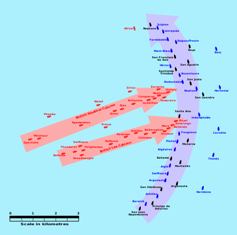
English: This map of the Battle of Trafalgar shows the approximate position of the two fleets at 1200 hours during the battle as the Royal Sovereign was breaking into the Franco-Spanish line. North is to the top, and Cape Trafalgar is 10 miles to the northeast. |
| Dato | |
| Fonto | own work made with Inkscape from Image:Trafalgar 1200hr.gif : This drawing is based on an illustration in issue number 84 of the Strategy & Tactics magazine The map was made by RJHall using the Campaign Cartographer drawing program, and the image was reduced in size 50% in Paint Shop Pro. Ship icons are not to scale. |
| Autoro | Pinpin |
Licencizo
Me, la proprietero dil autoroyuri pri ica verko, per to publikigos ol segun la sequanta yurizi:

|
On darfas kopiigar, distributar ed/od altrigar ica dokumento segun la kondicioni di GNU Free Documentation License, quale esas mencionita en la versiono 1.2 od en irga plu posa versiono, qua esas publikigita da Free Software Foundation; En la dokumento ne darfas esas ne-altrigita parti ed olu ne darfas esar kom texto di frontala o dopala pagino di libro o GNU Free Documentation License. |
Ca texto esas disponeebla sub licenco Creative Commons Attribution-Share Alike 3.0 Unported, 2.5 Komuna, 2.0 Komuna e 1.0 Komuna.
- Vu povas:
- partigar – kopiar, distributar e transsendar la verko
- Mixar – adaptar l'arkivo
- Segun la sequanta kondicioni:
- Atribuo – Vu mustas referar l'artiklo o verko segun la formo definita dal autoro o dal proprietero dil autoroyuro, ed informar se modifikuri facesis. Vu mustas facar to per justa formo, ma ne insinuar ke l'autoro konfidis ol a vu, od aprobis vua uzo dil artiklo.
- partigar identa ('share alike') – Se vu modifikos, transformos od augmentos ica verko, vu mustos distributar la rezulto segun la sama, o simila licenco, quale l'originalo.
Selektez l'yurizo quon vu preferas.
Historio dil arkivo
Kliktez sur la dato/horo por vidar arkivo quale ol aparis ye ta tempo.
| Dato/Horo | Miniaturo | Dimensioni | Uzero | Komento | |
|---|---|---|---|---|---|
| aktuala | 03:45, 29 jan. 2008 | | 743 × 735 (77 KB) | Uhanu | I forgot the colour of Belleisle. |
| 03:43, 29 jan. 2008 |  | 743 × 735 (77 KB) | Uhanu | Correcting some names: Montañés , San Ildefonso, Agamemnon, Duguay-Trouin... and colour of Belleisle. | |
| 18:55, 14 dec. 2007 |  | 743 × 735 (77 KB) | Rama | Original SVG version at Image:Trafalgar 1200hr.gif * '''Description:''' This map of the '''Battle of Trafalgar''' shows the approximate position of the two fleets at 1200 hours during the battle as the Royal Sovereign was breaking into the Franc | |
| 20:11, 3 okt. 2007 |  | 900 × 850 (73 KB) | Pinpin | I forget one boat | |
| 20:04, 3 okt. 2007 |  | 900 × 850 (72 KB) | Pinpin | {{Information |Description={{en|This map of the '''Battle of Trafalgar''' shows the approximate position of the two fleets at 1200 hours during the battle as the Royal Sovereign was breaking into the Franco-Spanish line. North is to the top, and Cape |
Ligilo al imajo
Ca pagini ligas al imajo:
Uzado en altra Wiki
La sequanta Wiki anke uzas ica arkivo:
- Uzado en azb.wikipedia.org
- Uzado en bg.wikipedia.org
- Uzado en ca.wikipedia.org
- Uzado en de.wikipedia.org
- Uzado en el.wikipedia.org
- Uzado en en.wikipedia.org
- Uzado en es.wikipedia.org
- Uzado en et.wikipedia.org
- Uzado en fi.wikipedia.org
- Uzado en he.wikipedia.org
- Uzado en hu.wikipedia.org
- Uzado en it.wikipedia.org
- Uzado en ja.wikipedia.org
- Uzado en nl.wikipedia.org
- Uzado en no.wikipedia.org
- Uzado en ro.wikipedia.org
- Uzado en ru.wikipedia.org
- Uzado en sr.wikipedia.org
- Uzado en sv.wikipedia.org
- Uzado en th.wikipedia.org
- Uzado en vi.wikipedia.org
- Uzado en www.wikidata.org