
Arkivo:Asia 800ad.jpg
Grandeso de ica previdado: 800 x 463 pixels. Altra qualeso, en pixel-i: 320 x 185 pixels | 640 x 370 pixels | 1 024 x 593 pixels | 1 280 x 741 pixels | 2 099 x 1 215 pixels.
Arkivo originala (2 099 × 1 215 pixel-i, grandeso dil arkivo: 809 KB, MIME type: image/jpeg)

|
Tiu ĉi bildo historical map respektive ĉiuj bildoj en tiu ĉi artikolo aŭ kategorio prefere estu rekreata(j) kiel vektora grafikaĵo en la formato SVG. Vektoraj formatoj por grafikaĵoj havas multajn avantaĝojn, detaloj troveblas anglalingve en la komuneja artikolo Commons:Media for cleanup. Se vi havas aŭ kreas SVG-version de tiu ĉi bildo, bonvolu alŝuti ĝin al la vikipedia komunejo. Post tiu ago, ĉi tiu ŝablono en la bildpaĝo estas anstataŭigenda per la ŝablono {{vector version available|nova dosiera nomo.svg}}.
|


Titulo
| Deskripto |
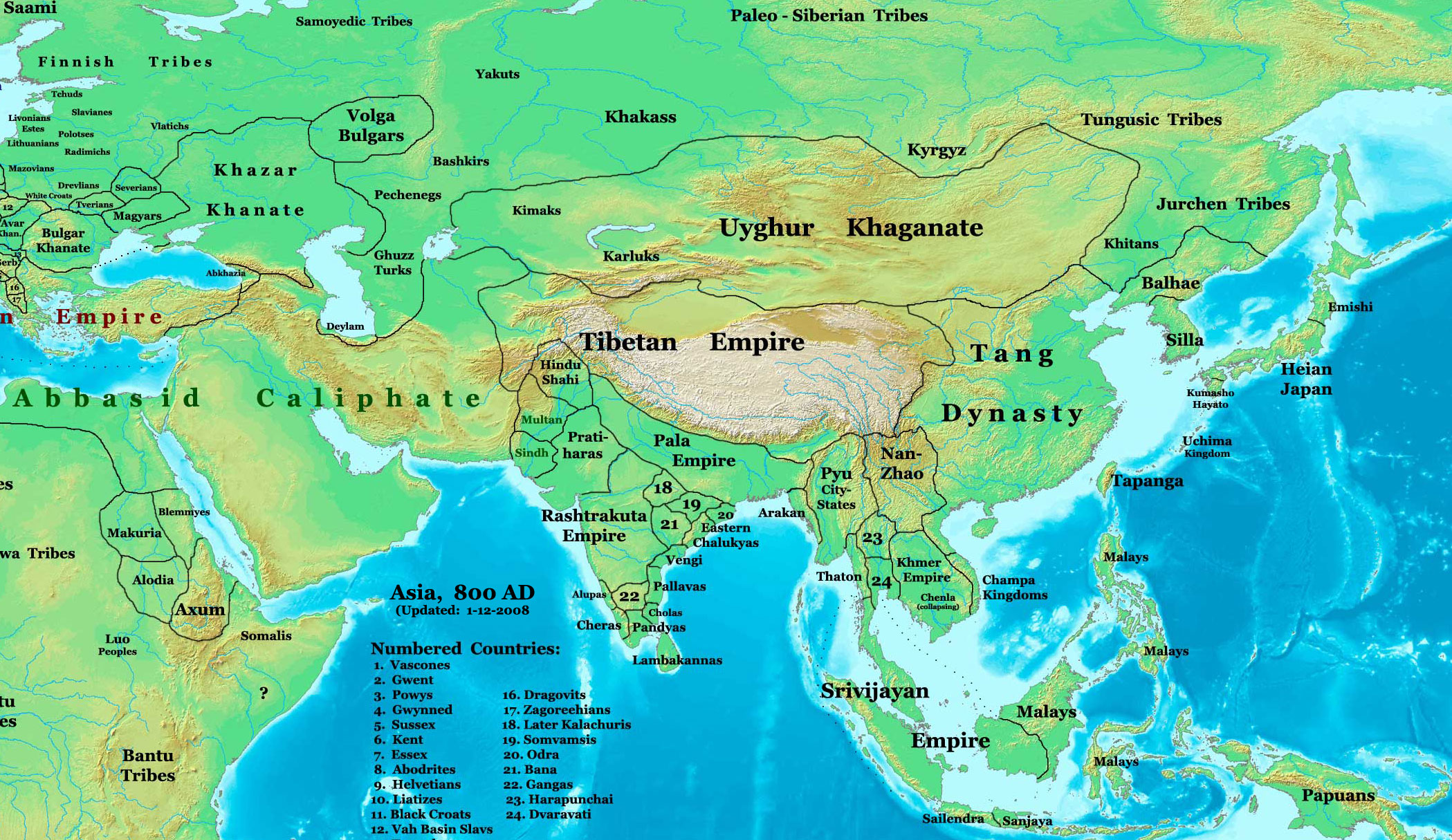
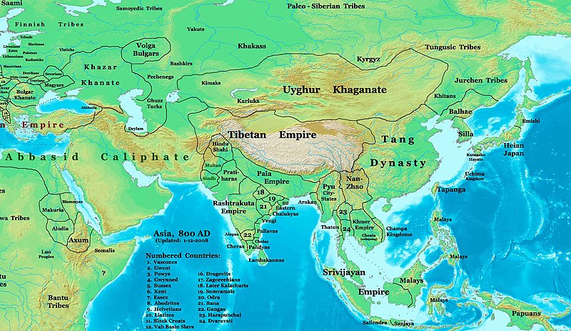
English: This image is a zoomed-in version of Image:East-Hem_800ad.jpg (Eastern Hemisphere in 800 AD).
Author: Thomas A. Lessman. Source URL: http://www.ThomasLessman.com/History/images/East-Hem_800ad.jpg. Image was created by me (Thomas Lessman) based on map of Eastern Hemisphere in 800 AD. Image is free for public and/or educational use. I would appreciate a mention if this image is used elsewhere. If anyone is interested in helping further this work, please contact Thomas Lessman at talessman@yis.us. Other Historical Maps by Thomas Lessman
|
| Dato | la 22-a de oktobro 2007 (origina alŝuta dato); la 29-a de januaro 2008 (last version) |
| Fonto | Transferred from en.wikipedia to Commons by Vinhtantran using CommonsHelper. |
| Autoro | Talessman de angla Wikipedio |
| Altra versioni |
 |


Licencizo
Talessman de angla Wikipedio, la posedanto de la aŭtorrajto por ĉi tiu verko, ĉi-maniere publikigas tiun laŭ la jenaj permesiloj:

|
On darfas kopiigar, distributar ed/od altrigar ica dokumento segun la kondicioni di GNU Free Documentation License, quale esas mencionita en la versiono 1.2 od en irga plu posa versiono, qua esas publikigita da Free Software Foundation; En la dokumento ne darfas esas ne-altrigita parti ed olu ne darfas esar kom texto di frontala o dopala pagino di libro o GNU Free Documentation License. |
Ca arkivo esas disponebla sub la licenco Creative Commons Attribution-Share Alike 3.0 Unported.
Atribuo: Talessman de angla Wikipedio
- Vu povas:
- partigar – kopiar, distributar e transsendar la verko
- Mixar – adaptar l'arkivo
- Segun la sequanta kondicioni:
- Atribuo – Vu mustas referar l'artiklo o verko segun la formo definita dal autoro o dal proprietero dil autoroyuro, ed informar se modifikuri facesis. Vu mustas facar to per justa formo, ma ne insinuar ke l'autoro konfidis ol a vu, od aprobis vua uzo dil artiklo.
Selektez l'yurizo quon vu preferas.
Originala protokolo dum sendado dil arkivo
The original description page was here. All following user names refer to en.wikipedia.
- 2008-01-29 22:50 Talessman 2099×1215×8 (828763 bytes) corrected borders of Tibet and others
- 2007-12-10 23:50 Talessman 2106×1450×8 (911289 bytes) (Correct image uploaded this time; earlier upload was the old version...)
- 2007-12-10 23:48 Talessman 1950×1193×8 (695931 bytes) Uploaded most recently corrected version (as of 12-09-2007)
- 2007-10-31 20:39 Talessman 1950×1193×8 (695931 bytes) Corrected borders of Korea, added info on Far eastern islands
- 2007-10-22 19:15 Talessman 1673×1062×8 (553343 bytes) Author: Thomas A. Lessman. Source URL: http://www.ThomasLessman.com/History/images/East-Hem_800ad.jpg. Image was created by me (Thomas Lessman) based on map of Eastern Hemisphere in 800AD. Image is free for public and/or educational use. I would appreciat
Historio dil arkivo
Kliktez sur la dato/horo por vidar arkivo quale ol aparis ye ta tempo.
| Dato/Horo | Miniaturo | Dimensioni | Uzero | Komento | |
|---|---|---|---|---|---|
| aktuala | 04:46, 23 jun. 2008 | | 2 099 × 1 215 (809 KB) | File Upload Bot (Magnus Manske) | {{BotMoveToCommons|en.wikipedia}} {{Information |Description={{en|This image is a zoomed-in version of [http://en.wikipedia.org/wiki/Image:East-Hem_800ad.jpg Eastern Hemisphere in 800 AD]. [[:en:Image:East-Hem_800ad.jpg|thumb|300px|left|Eastern Hemispher |
Ligilo al imajo
Nula pagino ligesas ad ica pagino.
Uzado en altra Wiki
La sequanta Wiki anke uzas ica arkivo:
- Uzado en azb.wikipedia.org
- Uzado en ba.wikipedia.org
- Uzado en bn.wikipedia.org
- Uzado en en.wikipedia.org
- Bangladesh
- West Bengal
- History of Bangladesh
- Jaisalmer
- Portal:Bangladesh
- Gauḍa (city)
- History of Bihar
- Śāntarakṣita
- Pataliputra
- History of Rajasthan
- Horses in East Asian warfare
- Jaisalmer State
- User:Joelton Ivson/Gather lists/24270 – India
- User:Gauravkumar4291/Notes/GS/Cul/Pala Empire
- Horses in ancient and Imperial China
- Uzado en fa.wikipedia.org
- Uzado en fr.wikipedia.org
- Uzado en hi.wikipedia.org
- Uzado en incubator.wikimedia.org
- Uzado en it.wikipedia.org
- Uzado en ka.wikipedia.org
- Uzado en kn.wikipedia.org
- Uzado en ko.wikipedia.org
- Uzado en mai.wikipedia.org
- Uzado en my.wikipedia.org
- Uzado en ne.wikipedia.org
- Uzado en pt.wikipedia.org
- Uzado en ru.wikipedia.org
- Uzado en sl.wikipedia.org
- Uzado en ta.wikipedia.org
- Uzado en te.wikipedia.org
- Uzado en tt.wikipedia.org
- Uzado en uk.wikipedia.org
- Uzado en vi.wikipedia.org