
Arkivo:China prefectural-level divisions and administrative divisions (PRoC claim).png

Grandeso de ica previdado: 759 x 600 pixels. Altra qualeso, en pixel-i: 304 x 240 pixels | 607 x 480 pixels | 972 x 768 pixels | 1 280 x 1 012 pixels | 2 560 x 2 023 pixels | 6 246 x 4 937 pixels.
Arkivo originala (6 246 × 4 937 pixel-i, grandeso dil arkivo: 987 KB, MIME type: image/png)


|
The boundaries on this map show the de facto situation. This is just one of several different views on the subject (see COM:NPOV). |

|
This image is expected to always be the most recent one. Feel free to update it when needed.
|

|
This file may be updated to reflect new information. If you wish to use a specific version of the file without new updates being mirrored, please upload the required version as a separate file. |
Titulo
| Priskribo |
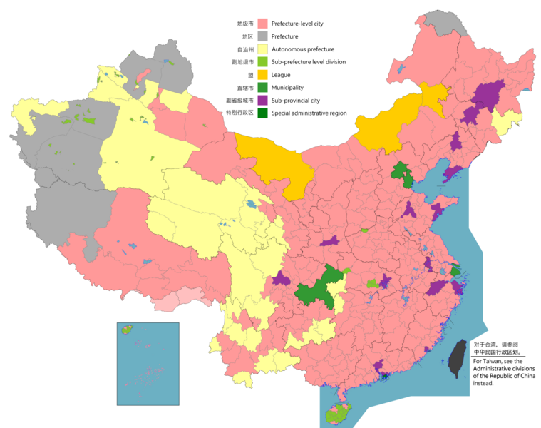
English: Map of China, shows provinces, prefecture-level divisions, etc.
日本語: 中国の地図、州、県レベルの区分などを示しています。
Русский: Карта Китая, показывает провинции, подразделения на уровне префектур и т. Д.
Монгол: Хятад улсын газрын зураг, мужууд, мужийн түвшний хэлтэс гэх мэтийг харуулсан.
中文(简体):中华人民共和国地图,显示省、地级区划等。(包含未实际控制之疆域)
中文(繁體):中華人民共和國地圖,顯示省、地級區劃等。 (包含未實際控制之疆域) |
||
| Map legend |
English:
Prefecture-level city
Prefecture
Autonomous prefecture
Sub prefecture-level division
League
Municipality
Sub-provincial city
Special administrative region 图例: 中文(简体):
地级市
地区
自治州
副地级市
盟
直辖市
副省级市
特别行政区 圖例: 中文(繁體): 地級市
地區
自治州
副地級市
盟
直轄市
副省級市
特別行政區 |
||
| Dato |
English: File uploaded: November 6, 2021
English: Original uploaded: September 12, 2011
Latest update: 07:09, 17 November 2023 中文(简体):原始上传时间2011年9月12日
中文(繁體):文件上传时间2021年11月6日
中文(繁體):原始上傳時間2011年9月12日 |
||
| Fonto |
English: Source appearances: 中文(简体):来源于: 中文(繁體):來源於:
[]
|
||
| Kreinto |
|
||
| Yurizo (Riuzo di ica arkivo) |
English: Map of China, administrative divisions: 中文(简体):中国地图,行政区划 中文(繁體):中國地圖,行政區劃 Me, la posedanto dil autoroyuro pri ica imajo/arkivo, permisos lua uzado camaniere:
|
||
| Geotemporal data | |||
| Montrata dato | as of February 4, 2021 | ||
| Spatial reference system | Custom | ||
| Georeferencing | |||
| Altra versioni |
English: Other languages: 中文(简体):其他语言: 中文(繁體):其他語言:
[]
Derivative works on these files: |
||


.png)
_sl.png)
.png)
Licencizo
Me, la posedanto dil autoroyuro pri ica imajo/arkivo, permisos lua uzado camaniere:
Ca arkivo esas disponebla sub la licenco Creative Commons Attribution-Share Alike 4.0 Internaciona.
- Vu povas:
- partigar – kopiar, distributar e transsendar la verko
- Mixar – adaptar l'arkivo
- Segun la sequanta kondicioni:
- Atribuo – Vu mustas referar l'artiklo o verko segun la formo definita dal autoro o dal proprietero dil autoroyuro, ed informar se modifikuri facesis. Vu mustas facar to per justa formo, ma ne insinuar ke l'autoro konfidis ol a vu, od aprobis vua uzo dil artiklo.
- partigar identa ('share alike') – Se vu modifikos, transformos od augmentos ica verko, vu mustos distributar la rezulto segun la sama, o simila licenco, quale l'originalo.

|
Tiu ĉi bildo locator map respektive ĉiuj bildoj en tiu ĉi artikolo aŭ kategorio prefere estu rekreata(j) kiel vektora grafikaĵo en la formato SVG. Vektoraj formatoj por grafikaĵoj havas multajn avantaĝojn, detaloj troveblas anglalingve en la komuneja artikolo Commons:Media for cleanup. Se vi havas aŭ kreas SVG-version de tiu ĉi bildo, bonvolu alŝuti ĝin al la vikipedia komunejo. Post tiu ago, ĉi tiu ŝablono en la bildpaĝo estas anstataŭigenda per la ŝablono {{vector version available|nova dosiera nomo.svg}}.
|
|
|
Tiu ĉi bildo map respektive ĉiuj bildoj en tiu ĉi artikolo aŭ kategorio prefere estu rekreata(j) kiel vektora grafikaĵo en la formato SVG. Vektoraj formatoj por grafikaĵoj havas multajn avantaĝojn, detaloj troveblas anglalingve en la komuneja artikolo Commons:Media for cleanup. Se vi havas aŭ kreas SVG-version de tiu ĉi bildo, bonvolu alŝuti ĝin al la vikipedia komunejo. Post tiu ago, ĉi tiu ŝablono en la bildpaĝo estas anstataŭigenda per la ŝablono {{vector version available|nova dosiera nomo.svg}}.
|
| Annotations | This image is annotated: View the annotations at Commons |
Historio dil arkivo
Kliktez sur la dato/horo por vidar arkivo quale ol aparis ye ta tempo.
.png&dir=prev)
.png&offset=20220128000854)
.png&offset=&limit=20)
.png&offset=&limit=50)
.png&offset=&limit=100)
.png&offset=&limit=250)
.png&offset=&limit=500)
| Dato/Horo | Miniaturo | Dimensioni | Uzero | Komento | |
|---|---|---|---|---|---|
| aktuala | 02:26, 11 di agosto. 2023 | | 6 246 × 4 937 (987 KB) | Vikarna | 州→地区 & 副地级划分→副地级市 |
| 08:59, 1 di agosto. 2023 |  | 6 246 × 4 937 (987 KB) | Maanshen | Add Baiyang county-level city | |
| 09:50, 1 dec. 2022 |  | 6 246 × 4 937 (987 KB) | Maanshen | Re-added disputed borders from the third version and removed the nine-dash line to prevent future bans to maps | |
| 05:28, 23 nov. 2022 |  | 6 246 × 4 937 (951 KB) | Vikarna | municipality 市政府→直辖市 | |
| 05:10, 23 nov. 2022 |  | 6 246 × 4 937 (986 KB) | Vikarna | League 联盟→盟 | |
| 23:06, 2 di agosto. 2022 |  | 6 246 × 4 937 (992 KB) | Maanshen | Update disputed/claimed borders, white with stroke is not claimed and filled in color is claimed | |
| 00:08, 20 apr. 2022 |  | 6 246 × 4 937 (975 KB) | Maanshen | Fix borders between Ili's Kuytun, Huyanghe, and Karamay | |
| 03:51, 1 mar. 2022 |  | 6 246 × 4 937 (975 KB) | Maanshen | Update Shanghai land reclamation | |
| 08:26, 28 jan. 2022 |  | 6 246 × 4 937 (975 KB) | Maanshen | Fix Changchun-Siping border | |
| 00:08, 28 jan. 2022 |  | 6 246 × 4 937 (975 KB) | Maanshen | Add parts of Tiemenguan |
Ligilo al imajo
Nula pagino ligesas ad ica pagino.
Uzado en altra Wiki
La sequanta Wiki anke uzas ica arkivo:
- Uzado en ast.wikipedia.org
- Uzado en bg.wikipedia.org
- Uzado en cs.wikipedia.org
- Uzado en en.wikipedia.org
- Uzado en es.wikipedia.org
- Uzado en fa.wikipedia.org
- Uzado en fi.wikipedia.org
- Uzado en fr.wikipedia.org
- Uzado en hu.wiktionary.org
- Uzado en id.wikipedia.org
- Uzado en incubator.wikimedia.org
- Uzado en ja.wikipedia.org
- Uzado en pt.wikipedia.org
- Uzado en ru.wikipedia.org
- Uzado en sh.wikipedia.org
- Uzado en si.wikipedia.org
- Uzado en sv.wikipedia.org
- Uzado en th.wikipedia.org
- Uzado en tr.wikipedia.org
- Uzado en ur.wikipedia.org
- Uzado en vi.wikipedia.org
- Uzado en www.wikidata.org
- Uzado en wuu.wikipedia.org
- Uzado en zh-yue.wikipedia.org
- Uzado en zh.wikipedia.org
Videz altra uzadi por ica artiklo.
.png)
.png)