
Arkivo:Great Lakes bathymetry map 2.png

Arkivo originala (1 024 × 731 pixel-i, grandeso dil arkivo: 943 KB, MIME type: image/png)
Titulo
| Deskripto |
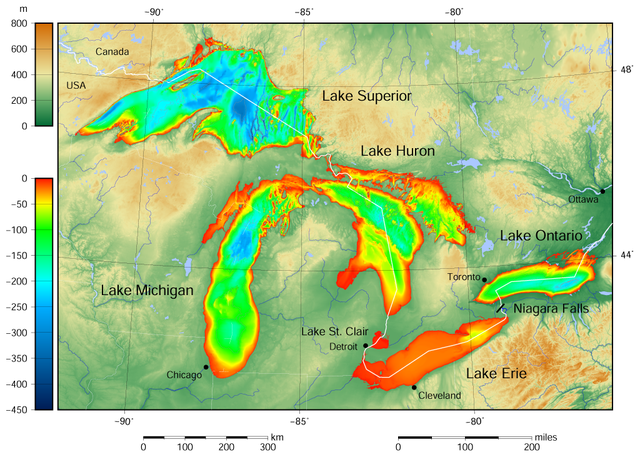
English: Great Lakes bathymetry and surrounding area relief map. Lakes are contoured with interval 100 m. Lake Superior is incomplete. |
| Dato | |
| Fonto |
Own work using: the following Public Domain datasets (grids):
The color palette of the depth scale was made to be more or less similar to the color palettes used on the NGDC Great Lakes maps. Ĉi tiu dosiero estas kreita per GMT. |
| Autoro | Darekk2 using the Great Lakes Bathymetry and GLOBE tiles |
| Altra versioni |
|

Licencizo
Attribution (in addition to the author of this map):
The NGDC in it's copyright notice says:
As required by 17 U.S.C. 403, third parties producing copyrighted works consisting predominantly of the material produced by U.S. government agencies must provide notice with such work(s) identifying the U.S. Government material incorporated and stating that such material is not subject to copyright protection within the United States. (...)
(for credits see the Source section).
and Great Lakes Bathymetry and GLOBE
(see above and the Source section)
- Vu povas:
- partigar – kopiar, distributar e transsendar la verko
- Mixar – adaptar l'arkivo
- Segun la sequanta kondicioni:
- Atribuo – Vu mustas referar l'artiklo o verko segun la formo definita dal autoro o dal proprietero dil autoroyuro, ed informar se modifikuri facesis. Vu mustas facar to per justa formo, ma ne insinuar ke l'autoro konfidis ol a vu, od aprobis vua uzo dil artiklo.
- partigar identa ('share alike') – Se vu modifikos, transformos od augmentos ica verko, vu mustos distributar la rezulto segun la sama, o simila licenco, quale l'originalo.
Historio dil arkivo
Kliktez sur la dato/horo por vidar arkivo quale ol aparis ye ta tempo.
| Dato/Horo | Miniaturo | Dimensioni | Uzero | Komento | |
|---|---|---|---|---|---|
| aktuala | 15:49, 9 may. 2015 | | 1 024 × 731 (943 KB) | Darekk2 | more accurate shorelines, the lakes tiles better assembled, added Canada, USA and Lake St. Clair labels, moved Detroit label, Michigan Lake - retouched western part of Green Bay |
| 01:35, 25 mar. 2015 |  | 1 024 × 731 (940 KB) | Darekk2 | User created page with UploadWizard |
Ligilo al imajo
Ca pagini ligas al imajo:
Uzado en altra Wiki
La sequanta Wiki anke uzas ica arkivo:
- Uzado en pl.wikipedia.org
- Uzado en www.wikidata.org