Irez a kontenajo

Arkivo:East and West Florida 1810.jpg

Paĝenhavo ne ekzistas en aliaj lingvoj.
De Wikipedio

East_and_West_Florida_1810.jpg (412 × 245 pixel-i, grandeso dil arkivo: 44 KB, MIME type: image/jpeg)

Ca arkivo jacas en Wikimedia Commons, e povas uzesar en altra projeti. La deskriptado en lua pagino di deskriptado montresas adinfre.

Deskripto
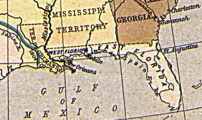
English: Map of East and West Florida in 1810, from the Perry-Castañeda Map Collection [1]. The boundary between the two provinces is incorrect; it was at the Apalachicola River, not the Perdido River (as shown here).
Español: Mapa de Florida Oriental y Florida Occidental en 1810, de la Collección Perry-Castañeda de Mapas[2]. La frontera entre las dos provincias no es correcto; la frontera era el Rio Apalachicola, no el Perdido (como se aparece aquí).
Deutsch: Karte von Ost- und Westflorida 1810. Aus der Kartensammlung der Perry-Castañeda Bibliothek[3]. Die Grenze zwischen Ost- und Westflorida ist unrichtig; die richtige Grenze war der Apalachicola-Fluss anstatt dem Perdido.
Français : Carte de Floride occidentale et de Floride orientale en 1810, provenant de la collection cartographique Perry-Castañeda [4]. La frontière indiquée entre les deux provinces est erronée : elle était formée par le fleuve Apalachicola, et non le fleuve Perdido représenté ici.
Dato 1923. Provided on 11 August 2005 by en:User:JW1805 to the English Wikipedia.
Fonto From "The Historical Atlas" by William R. Shepherd, 1923. http://www.lib.utexas.edu/maps/historical/shepherd/us_expansion_shepherd.jpg
Autoro
William Robert Shepherd  (1871–1934)  wikidata:Q8017647 s:en:Author:William Robert Shepherd
 
William Robert Shepherd
Altri nomi
William R. Shepherd; William Shepherd
Deskripto Usana kartografiisto ed historian
Data di nascita/morte la 12-a de junio 1871 Edit this at Wikidata la 7-a de junio 1934 Edit this at Wikidata
Luogo di nascita/morte Charleston Berlin
Luogo di attività
Norma datumaro
creator QS:P170,Q8017647


Public domain

Tiu ĉi verko estas publika havaĵo en tiuj landoj, kies kopirajtado validas por longo de vivo plus 70 jaroj aŭ malpli.


You must also include a United States public domain tag to indicate why this work is in the public domain in the United States.

Historio dil arkivo

Kliktez sur la dato/horo por vidar arkivo quale ol aparis ye ta tempo.

Dato/HoroMiniaturoDimensioniUzeroKomento
aktuala13:30, 20 di agosto. 2005Imajeto di versiono ye 13:30, 20 di agosto. 2005412 × 245 (44 KB)Sebastian Wallroth'''en: ''' Map of East and West Florida in 1810. From the Perry-Castañeda Library Map Collection [http://www.lib.utexas.edu/maps/historical/shepherd/us_expansion_shepherd.jpg]. '''de:''' Karte von Ost- und Westflorida 1810. Aus der Kartensammlung der

Ca pagini ligas al imajo:

Uzado en altra Wiki

La sequanta Wiki anke uzas ica arkivo:

Metadonaji