
Arkivo:Kansai closeup.jpg
Ne existas grandeso plu granda.
Kansai_closeup.jpg (800 × 600 pixel-i, grandeso dil arkivo: 66 KB, MIME type: image/jpeg)
Titulo
| Deskripto |
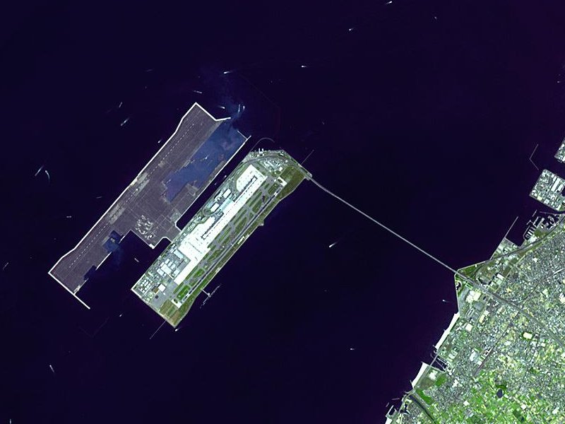
Satellite image of Kansai International Airport in Osaka Bay in Japan. This is a closeup - for an overview image showing the airport on its artificial island in the bay, see Image:Wfm kansai overview.jpg |
| Dato | |
| Fonto |
Taken from an uncopyrighted image NASA Earth Observatory |
| Autoro | NASA Earth Observatory |
| Yurizo (Riuzo di ica arkivo) |
"The purpose of NASA's Earth Observatory is to provide a freely-accessible publication on the Internet where the public can obtain new satellite imagery and scientific information about our home planet. The focus is on Earth's climate and environmental change. In particular, we hope our site is useful to public media and educators. Any and all materials published on the Earth Observatory are freely available for re-publication or re-use, except where copyright is indicated. We ask that NASA's Earth Observatory be given credit for its original materials." |
| Altra versioni |

| Pozicio de la objekto | | Tiu cxi bildo kaj pliaj sur OpenStreetMap |
|---|
Licencizo
| La ĉi-supra dosiero estas publika havaĵo, ĉar ĝi apartenas al NASA. La kopirajta regularo de NASA asertas, ke "ĉiuj dokumentoj de NASA estas publika havaĵo, se ne estas donata kontraŭa deklaro". | ||
 |
Atentu:
|
en.Wikipedia upload log
The en.Wikipedia description page is/was here. All following user names refer to en.Wikipedia.
- 2004-04-05 19:30 Finlay McWalter 800×600 (66 KB) (nasa image of kansai airport)
Historio dil arkivo
Kliktez sur la dato/horo por vidar arkivo quale ol aparis ye ta tempo.
| Dato/Horo | Miniaturo | Dimensioni | Uzero | Komento | |
|---|---|---|---|---|---|
| aktuala | 03:46, 13 dec. 2005 | | 800 × 600 (66 KB) | Sam916~commonswiki | Satellite image of Kansai International Airport in Osaka Bay in Japan. This is a closeup - for an overview image showing the airport on its artificial island in the bay, see Image:Wfm kansai overview.jpg Taken from an uncopyrighted imag |
Ligilo al imajo
Ca pagini ligas al imajo:
Uzado en altra Wiki
La sequanta Wiki anke uzas ica arkivo:
- Uzado en ar.wikipedia.org
- Uzado en ast.wikipedia.org
- Uzado en bbc.wikipedia.org
- Uzado en bg.wikipedia.org
- Uzado en bh.wikipedia.org
- Uzado en bn.wikipedia.org
- Uzado en de.wikipedia.org
- Uzado en el.wikipedia.org
- Uzado en en.wikipedia.org
- Uzado en en.wikibooks.org
- Uzado en es.wikipedia.org
- Uzado en eu.wikipedia.org
- Uzado en fa.wikipedia.org
- Uzado en fi.wikipedia.org
- Uzado en he.wikipedia.org
- Uzado en hu.wikipedia.org
- Uzado en id.wikipedia.org
- Uzado en it.wikipedia.org
- Uzado en it.wikivoyage.org
- Uzado en ja.wikipedia.org
- Uzado en ko.wikipedia.org
- Uzado en lfn.wikipedia.org
- Uzado en ml.wikipedia.org
- Uzado en mn.wikipedia.org
- Uzado en ms.wikipedia.org
- Uzado en nl.wikipedia.org
- Uzado en pt.wikipedia.org
- Uzado en ro.wikipedia.org
- Uzado en simple.wikipedia.org
- Uzado en sl.wikipedia.org
- Uzado en sr.wikipedia.org
- Uzado en sv.wikipedia.org
- Uzado en ta.wikipedia.org
- Uzado en uk.wikipedia.org
- Uzado en vi.wikipedia.org
- Uzado en www.wikidata.org
- Uzado en zh-yue.wikipedia.org
- Uzado en zh.wikipedia.org
Videz altra uzadi por ica artiklo.